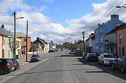
Ballyporeen
|
Ballyporeen Béal Átha Póirin
|
|
|---|---|
| Village | |

The R665 through Ballyporeen, once part of the main Dublin - Cork coach road.
|
|
| Location in Ireland | |
| Coordinates: 52°16′12″N 8°06′00″W / 52.26994°N 8.10001°WCoordinates: 52°16′12″N 8°06′00″W / 52.26994°N 8.10001°W | |
| Country | Ireland |
| Province | Munster |
| County | County Tipperary |
| Dáil Éireann | Tipperary South |
| Elevation | 82 m (269 ft) |
| Population (2006) | |
| • Total | 304 |
| Dialing code | 0 52, +000 353 (0)52 |
| Irish Grid Reference | R930132 |
| Website | ballyporeenvillage |
Ballyporeen (Irish: Béal Átha Póirín) is a village in County Tipperary, Ireland. The national census of 2006 recorded the population of Ballyporeen at 304 with an additional 573 in its rural hinterland.
It lies in the Galtee-Vee Valley with the Galtee Mountains to the north and the Knockmealdowns to the south. The River Duag which is a tributary of the Suir runs through the village. It is located on the R665 regional road. The nearest large towns are Mitchelstown and Cahir, which are 12 km and 21 km respectively.
The village is approximately 11 km from Junction 12 of the M8 Motorway.
During the week, it is served five times a day in each direction by Bus Éireann route 245 linking it to Clonmel, Mitchelstown, Fermoy and Cork. During the weekend, there are three buses each way.
The origins of the name are not definitively understood. The most accepted Irish translation is the "Ford Mouth of the Round Stones". Those stones may have been river deposits or dye stones left there by inhabitants from a cloth dyeing process.
Another theory is the original name got corrupted and ambiguated over time; a 1618 document referred to "Bealanporan", this and possible previous forms would alter its meaning. One respected historian believed 'Powers-town' was the correct translation of its origins. An Anglo-Norman family called Power did have connections with the area.
The birth of Ballyporeen as a nucleated settlement is unknown. Up until the 18th Century, Carrigvisteal (approx 1.5 km north of the village) was the main settlement node in the area.
...
Wikipedia

