Ballwin, MO
| Ballwin, Missouri | |
|---|---|
| City | |
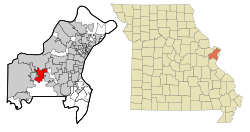
 Location of Ballwin in St. Louis County and Missouri |
|
| Coordinates: 38°35′41″N 90°32′54″W / 38.59472°N 90.54833°WCoordinates: 38°35′41″N 90°32′54″W / 38.59472°N 90.54833°W | |
| Country |
|
| State |
|
| County | St. Louis |
| Incorporated | December 29, 1950 |
| Government | |
| • Mayor | Tim Pogue |
| Area | |
| • Total | 8.99 sq mi (23.28 km2) |
| • Land | 8.99 sq mi (23.28 km2) |
| • Water | 0 sq mi (0 km2) |
| Elevation | 630 ft (192 m) |
| Population (2010) | |
| • Total | 30,404 |
| • Estimate (2015) | 30,577 |
| • Density | 3,382.0/sq mi (1,305.8/km2) |
| Time zone | Central (CST) (UTC-6) |
| • Summer (DST) | CDT (UTC-5) |
| FIPS code | 29-03160 |
| GNIS feature ID | 0755721 |
| Website | ballwin.mo.us |
Ballwin is a second-ring western suburb of St. Louis, located in St. Louis County, Missouri, United States. The population was 30,404 as of the 2010 census. It was named by Money magazine in 2005, 2011, and 2013 as one of the 100 best places to live in America.
Ballwin was laid out in 1837. The community was named for John Ball, who settled at the town site in 1804. A post office called Ballwin has been in operation since 1866.
Ballwin is located at 38°35′41″N 90°32′54″W / 38.59472°N 90.54833°W (38.594820, −90.548420). According to the United States Census Bureau, the city has a total area of 8.99 square miles (23.28 km2), all of it land.
As of the census of 2010, there were 30,404 people, 11,874 households, and 8,631 families residing in the city. The population density was 3,382.0 inhabitants per square mile (1,305.8/km2). There were 12,435 housing units at an average density of 1,383.2 per square mile (534.1/km2). The racial makeup of the city was 89.3% White, 2.5% African American, 0.2% Native American, 5.6% Asian, 0.6% from other races, and 1.7% from two or more races. Hispanic or Latino of any race were 2.4% of the population.
...
Wikipedia
