Bald Eagle Mountain
| Bald Eagle Mountain | |
|---|---|

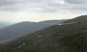
A Scimitar glider ridge soaring on Bald Eagle Mountain near Lock Haven, Pennsylvania
|
|
| Highest point | |
| Elevation | 2,008 ft (612 m) |
| Coordinates | 41°08′14″N 77°19′38″W / 41.13722°N 77.32722°WCoordinates: 41°08′14″N 77°19′38″W / 41.13722°N 77.32722°W |
| Geography | |
| Location | Pennsylvania, U.S. |
| Parent range | Appalachian Mountains |
| Topo map | USGS Jersey Shore (PA) Quadrangle |
Bald Eagle Mountain – once known locally as Muncy Mountain – is a stratigraphic ridge in the Allegheny Mountains of central Pennsylvania, USA, running east of the Allegheny Front and northwest of Mount Nittany. It lies along the southeast side of Bald Eagle Creek, and south of the West Branch Susquehanna River, and is the westernmost ridge in its section of the Ridge-and-valley Appalachians. The ridge line separates the West Branch Susquehanna Valley from the Nippenose and White Deer Hole Valleys, and Bald Eagle Valley from Nittany Valley.
Bald Eagle Mountain lies in the central portion of Centre County, the southern portion of Clinton County, the southern portion of Lycoming County, and the ridge line forms part of the border between Blair County and Huntingdon County. It runs from the water gap formed with Brush Mountain by the Little Juniata River at Tyrone, to the bend in the West Branch Susquehanna River just east of Williamsport, a distance of approximately 60 miles (100 km).
...
Wikipedia

