Bala, Ontario
| Bala | |
|---|---|
| Town | |

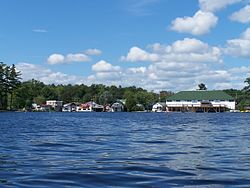
The southern portion of the town as viewed from Bala Bay, the KEE to Bala is visible (right)
|
|
| Coordinates: 45°01′N 79°55′W / 45.017°N 79.917°W | |
| Country |
|
| Province |
|
| District | Muskoka |
| Municipality | Muskoka Lakes |
| Time zone | EST (UTC-5) |
| • Summer (DST) | EDT (UTC-4) |
| Postal Code | P0C |
| Area code(s) | 705 |
Bala is a Canadian community famous for the Bala Falls. It is located in Muskoka Lakes Township in Ontario, where Lake Muskoka empties into the Moon River.
It is considered one of the hubs of cottage country located north of Toronto. Thus, its year-round population of several hundred is increased by thousands of seasonal residents and weekend day-trippers during summer months. It is known as the Cranberry Capital of Ontario, as the province's largest cranberry farms, Johnston's Cranberry Marsh and Wahta Iroquis Growers, are located nearby. It was once the smallest incorporated town in Canada, until amalgamation as part of Muskoka Lakes Township.
Bala was settled by Thomas Burgess in 1868. Thomas Burgess opened a sawmill and store to serve the area's scattered settlers. Thomas Burgess named it after the town of Bala in Wales with which it is officially twinned. Located on the Canadian Shield, it proved unsuitable for farming and its fortunes declined as logging became less economically viable. Railway connections helped to re-establish the village as a popular location for summer resorts.
In 1914, the town incorporated with Burgess' son as the first mayor making it the smallest incorporated town in Canada.
Located at the west end of Lake Muskoka, at the foot of Bala Bay, the prominent geographical feature of the town are the many bare outcroppings of the Canadian Shield. Carved out of the Shield is Bala Falls, the only outlet for Lake Muskoka. This allows water to empty from the Muskoka River watershed into the Moon River and eventually Georgian Bay; however, the falls were at a low elevation and for many years the water levels of Lake Muskoka were known to fluctuate eight or nine feet every season, between the spring runoffs and the late fall. This led to many navigation problems both for the timber industry and the settlers. In 1873 a control dam was built at the Bala Falls, which still exists in an upgraded form and is known as the North Falls. However, the dam worked too well and led to flooding, which forced the construction soon after of a large flood control dam and channel, known today as the South Falls.
...
Wikipedia

