Babinda
|
Babinda Queensland |
|||||||||||||||
|---|---|---|---|---|---|---|---|---|---|---|---|---|---|---|---|

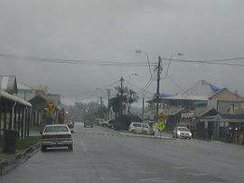
Babinda on a typical rainy day
|
|||||||||||||||
| Coordinates | 17°20′42″S 145°55′30″E / 17.34500°S 145.92500°ECoordinates: 17°20′42″S 145°55′30″E / 17.34500°S 145.92500°E | ||||||||||||||
| Population | 1,068 (2011 census) | ||||||||||||||
| Postcode(s) | 4861 | ||||||||||||||
| Location | |||||||||||||||
| LGA(s) | Cairns Region | ||||||||||||||
| State electorate(s) | Mulgrave | ||||||||||||||
| Federal Division(s) | Kennedy | ||||||||||||||
|
|||||||||||||||
|
|||||||||||||||
Babinda is a small town and suburb in the Cairns Region, Queensland, Australia. It is located 60 kilometres (37 mi) south of Cairns. At the 2011 census the town recorded a population of 1,068.
The town is noted for its proximity to Queensland's two highest mountains Mount Bartle Frere and Mount Bellenden Ker.
Babinda and Tully annually compete for the Golden Gumboot, an award for Australia's wettest town. Babinda is usually the winner, recording an annual average rainfall of over 4279.4 millimetres each year.
Babinda takes its name from the local Indigenous Australian language for mountain. Other sources, however, claim it is a Yidinji word for water, possibly referring to the high rainfall of the area.
Babinda State School opened on 4 November 1914.
Babinda Post Office opened by 1915 (a Babinda Creek receiving office had been open since 1891).
The Babinda War Memorial was unveiled by the chairman of the Cairns Shire Council Seymour Warner on 25 April 1927.
In March 2006, Babinda was struck by Cyclone Larry, damaging up to 80% of buildings.
Babinda has a number of heritage-listed sites, including:
The 2006 Census by the Australian Bureau of Statistics counted 1,167 persons in Babinda on census night. Of these, 49.7% were male and 50.3% were female.
The majority of residents (79.7%) are of Australian birth, with other common census responses being Italy (2.7%) and New Zealand (2.0%).
...
Wikipedia

