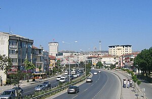
Büyükçekmece
| Büyükçekmece | |
|---|---|
| district | |

The district of Büyükçekmece
|
|
 Location of Büyükçekmece in Istanbul |
|
| Location of Büyükçekmece in Istanbul | |
| Coordinates: 41°01′12″N 28°34′39″E / 41.02000°N 28.57750°ECoordinates: 41°01′12″N 28°34′39″E / 41.02000°N 28.57750°E | |
| Country | Turkey |
| City | Istanbul |
| Government | |
| • Mayor | Hasan Akgün (CHP) |
| • Governor | Ismail Gündüz |
| Area | |
| • District | 239.25 km2 (92.37 sq mi) |
| Population (2012) | |
| • District | 201,077 |
| • District density | 840/km2 (2,200/sq mi) |
| Time zone | EET (UTC+2) |
| • Summer (DST) | EEST (UTC+3) |
| Postal Code | 34537 |
| Area code(s) | 0-212 |
| Website |
www |
Büyükçekmece is a district and municipality () in the suburbs of Istanbul, Turkey on the Sea of Marmara coast of the European side, west of the city. It is largely an industrial area with a population of 380,000. The mayor is Hasan Akgün (CHP).
The land around this inlet of the Sea of Marmara, has been settled, abandoned and resettled throughout history as army after army passed along the coast to Istanbul. It is thought to be the site of the Greek colony on the Marmara shore called Athyra (Άθυρα), also known as Athyras.
In 443 AD, the armies of Attila the Hun took this settlement and its associated fort, and this was presumably his last conquest of that campaign before turning around.
The earliest mention of the bishopric of Athyra in a list of dioceses is of the late 15th century, but a seal has been found of a 10th-century Bishop Orestes of the see. No longer a residential bishopric, Athyra is today listed by the Catholic Church as a titular see.
The Ottoman architect Mimar Sinan built a bridge to cross the mouth of the inlet (Lake Büyükçekmece) and there are ruins of inns and caravansarai, which show this was a stopping place on the road to Europe. At the beginning of the Ottoman period, it was empty forest and farmland, and has gradually been settled by Turkish people migrating in from the Balkans and the Caucasus.
...
Wikipedia

