Båtsfjord Municipality
|
Båtsfjord kommune Báhcavuona gielda |
|||
|---|---|---|---|
| Municipality | |||

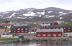
View of Båtsfjord village
|
|||
|
|||
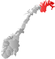
 Båtsfjord within Finnmark |
|||
| Coordinates: 70°38′07″N 29°43′15″E / 70.63528°N 29.72083°ECoordinates: 70°38′07″N 29°43′15″E / 70.63528°N 29.72083°E | |||
| Country | Norway | ||
| County | Finnmark | ||
| District | Øst-Finnmark | ||
| Administrative centre | Båtsfjord | ||
| Government | |||
| • Mayor (2011) | Geir Knutsen (Ap) | ||
| Area | |||
| • Total | 1,434.72 km2 (553.95 sq mi) | ||
| • Land | 1,416.00 km2 (546.72 sq mi) | ||
| • Water | 18.72 km2 (7.23 sq mi) | ||
| Area rank | 58 in Norway | ||
| Population (2017) | |||
| • Total | 2,267 | ||
| • Rank | 314 in Norway | ||
| • Density | 1.6/km2 (4/sq mi) | ||
| • Change (10 years) | 7.3 % | ||
| Demonym(s) | Båtsfjording | ||
| Time zone | CET (UTC+1) | ||
| • Summer (DST) | CEST (UTC+2) | ||
| ISO 3166 code | NO-2028 | ||
| Official language form | Neutral | ||
| Website | www |
||
|
|
|||
Båtsfjord (Northern Sami: Báhcavuotna) is a municipality in Finnmark county, Norway. The administrative centre of the municipality is the village of Båtsfjord. It is the only settlement in the municipality. Båtsfjord Airport is a new, modern airport, located just outside Båtsfjord village. The Hurtigruten coastal express ferry also has regularly-scheduled stops in Båtsfjord village.
The 1,435-square-kilometre (554 sq mi) municipality is the 58th largest by area out of the 426 municipalities in Norway. Båtsfjord is the 314th most populous municipality in Norway with a population of 2,267. The municipality's population density is 1.6 inhabitants per square kilometre (4.1/sq mi) and its population has increased by 7.3% over the last decade.
Historically, there were many other villages in the municipality, but they have been abandoned over the years. Some of these villages include Hamningberg (abandoned in 1964), Makkaur (abandoned in the 1950s), Sandfjord/Ytre Syltefjord (abandoned in 1946), Hamna (abandoned around 1950), and Nordfjord (abandoned in 1989).
Vardø Municipality was established on 1 January 1838 (see formannskapsdistrikt), encompassing the northeastern part of the Varanger Peninsula. In 1839, to comply with the formannskapsdistrikt law, the rural parts of the municipality, outside of the island/town of Vardø, were separated to form the new municipality of Vardø landdistrikt. Initially, Vardø landdistrikt had a population of 245. The new municipality was too small to be an official self-governing municipality, and it was not until 22 May 1868 when a royal resolution was passed that officially declared it a self-governing municipality. On 1 January 1874, a small part of Vardø landdistrikt (population: 48) was transferred to the town of Vardø. On 1 January 1955, the name was changed to Båtsfjord. On 1 January 1964, the eastern fourth of Båtsfjord (population: 621) was transferred to the neighboring Vardø Municipality.
...
Wikipedia


