Vardø (town)
|
Vardø Vuorea Várggát |
|
|---|---|
| Village | |

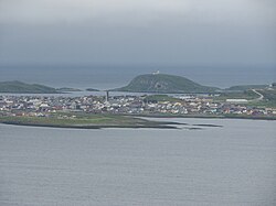
View of the town from the mainland
|
|
| Location in Finnmark | |
| Coordinates: 70°22′13″N 31°06′38″E / 70.37028°N 31.11056°ECoordinates: 70°22′13″N 31°06′38″E / 70.37028°N 31.11056°E | |
| Country | Norway |
| Region | Northern Norway |
| County | Finnmark |
| District | Øst-Finnmark |
| Municipality | Vardø |
| Area | |
| • Total | 1.15 km2 (0.44 sq mi) |
| Elevation | 9 m (30 ft) |
| Population (2013) | |
| • Total | 1,893 |
| • Density | 1,646/km2 (4,260/sq mi) |
| Time zone | CET (UTC+01:00) |
| • Summer (DST) | CEST (UTC+02:00) |
| Post Code | 9950 Vardø |
![]() Vardø (Kven: Vuorea; Northern Sami: Várggát) is a town and the administrative centre of Vardø Municipality in Finnmark county, Norway. The town is located on the island of Vardøya in the Barents Sea, just off the coast of the large Varanger Peninsula. The 1.15-square-kilometre (280-acre) town has a population (2013) of 1,893, which gives it a population density of 1,646 inhabitants per square kilometre (4,260/sq mi).
Vardø (Kven: Vuorea; Northern Sami: Várggát) is a town and the administrative centre of Vardø Municipality in Finnmark county, Norway. The town is located on the island of Vardøya in the Barents Sea, just off the coast of the large Varanger Peninsula. The 1.15-square-kilometre (280-acre) town has a population (2013) of 1,893, which gives it a population density of 1,646 inhabitants per square kilometre (4,260/sq mi).
Vardø is the easternmost town in Norway (and in all the Nordic countries), located at 31°E, which is east of Saint Petersburg, Kiev, and Istanbul. The eastern part of Finnmark is in the same time zone as the rest of the country, but it is more than an hour at odds with daylight hours.
The largest industry in the town is fishing and fish processing. There is a good port in Vardø, and another port in nearby Svartnes, on the mainland. The town is connected to the mainland by the undersea Vardø Tunnel which is part of European route E75. Vardø Airport, Svartnes is located at the other end of the tunnel on the mainland.
...
Wikipedia

