Axtell, Nebraska
| Axtell, Nebraska | |
|---|---|
| Village | |

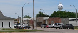
Downtown Axtell: east side of Main Street
|
|
| Nickname(s): The Windmill City | |
 Location of Axtell, Nebraska |
|
| Coordinates: 40°28′48″N 99°7′38″W / 40.48000°N 99.12722°WCoordinates: 40°28′48″N 99°7′38″W / 40.48000°N 99.12722°W | |
| Country | United States |
| State | Nebraska |
| County | Kearney |
| Incorporated | 1885 |
| Area | |
| • Total | 0.44 sq mi (1.14 km2) |
| • Land | 0.44 sq mi (1.14 km2) |
| • Water | 0 sq mi (0 km2) |
| Elevation | 2,224 ft (678 m) |
| Population (2010) | |
| • Total | 726 |
| • Estimate (2012) | 718 |
| • Density | 1,650.0/sq mi (637.1/km2) |
| Time zone | Central (CST) (UTC-6) |
| • Summer (DST) | CDT (UTC-5) |
| ZIP code | 68924 |
| Area code(s) | 308 |
| FIPS code | 31-02830 |
| GNIS feature ID | 0835239 |
Axtell is a village in Kearney County, Nebraska, United States. It is part of the Kearney, Nebraska Micropolitan Statistical Area. The population was 726 at the 2010 census.
The first settlement at Axtell was made in the 1870s. Axtell was incorporated as a village in 1885 when the Burlington & Missouri River Railroad was extended to that point. It was named for a railroad worker.
Axtell is located at 40°28′48″N 99°7′38″W / 40.48000°N 99.12722°W (40.479905, -99.127265).
According to the United States Census Bureau, the village has a total area of 0.44 square miles (1.14 km2), all of it land.
As of the census of 2010, there were 726 people, 276 households, and 208 families residing in the village. The population density was 1,650.0 inhabitants per square mile (637.1/km2). There were 293 housing units at an average density of 665.9 per square mile (257.1/km2). The racial makeup of the village was 97.4% White, 0.6% Native American, 0.1% Asian, 0.8% from other races, and 1.1% from two or more races. Hispanic or Latino of any race were 1.2% of the population.
...
Wikipedia
