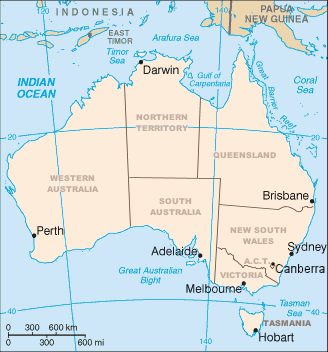
Australian states and territories
| Australian states and territories | |
|---|---|
| Category |
Federated states (6) Internal federal territories (3) External federal territories (7) |
| Location | Commonwealth of Australia |
| Populations | 0 (Ashmore and Cartier Islands, Heard and McDonald Islands) – 7,704,300 (New South Wales) |
| Areas | 10 km2 (3.9 sq mi) (Coral Sea Islands) – 5,896,500 km2 (2,276,700 sq mi) (Australian Antarctic Territory) |
| Subdivisions |
Local government areas Cadastral divisions |
Australia (officially known as the Commonwealth of Australia) is a federation of six states, together with ten federal territories. The Australian mainland consists of five of the six federated states and three of the federal territories (the "internal" territories). The state of Tasmania is an island about 200 kilometers from the mainland. The remaining seven territories are classified for some purposes as "external" territories. Aside from the Australian Antarctic Territory, which is Australia's claim to part of Antarctica, Australia is the world's sixth-largest country by total area.
All states and the two largest internal territories are partially self-governing, as well as being represented in the federal parliament; the other territories are administered by the federal government. Since 2015, federal control has also been extended to the formerly self-governing territory of Norfolk Island. Three of the external territories are inhabited; the others are uninhabited, apart from non-permanent scientists.
The term geographic Australia is used by the Australian government to describe the area covered by demographic statistics such as national population figures. This area comprises Christmas Island and the Cocos (Keeling) Islands in addition to the six states and three mainland territories. Norfolk Island is the only territory with a native population that is not part of geographic Australia.
See also: List of State codes
Australia has had three now-defunct territories in its history:
The states originated as separate British colonies prior to Federation in 1901. The Colony of New South Wales was founded in 1788 and originally comprised much of the Australian mainland, as well as Lord Howe Island, New Zealand, Norfolk Island, and Van Diemen's Land, in addition to the area currently referred to as the state of New South Wales. During the 19th century, large areas were successively separated to form the Colony of Tasmania (initially established as a separate colony named Van Diemen's Land in 1825), the Colony of Western Australia (initially established as the smaller Swan River Colony in 1829), the Province of South Australia (1836), the Colony of New Zealand (1840), the Victoria Colony (1851) and the Colony of Queensland (1859). Upon Federation, the six colonies of New South Wales, Victoria, Queensland, South Australia, Western Australia, and Tasmania became the founding states of the new Commonwealth of Australia.
...
Wikipedia

