Aurelle-Verlac
| Aurelle-Verlac | ||
|---|---|---|

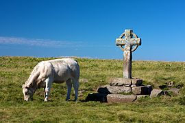
Wayside Cross in Aurelle-Verlac
|
||
|
||
| Coordinates: 44°30′25″N 3°00′29″E / 44.5069°N 3.0081°ECoordinates: 44°30′25″N 3°00′29″E / 44.5069°N 3.0081°E | ||
| Country | France | |
| Region | Occitanie | |
| Department | Aveyron | |
| Arrondissement | Rodez | |
| Canton | Lot et Palanges | |
| Intercommunality | Pays d'Olt et d'Aubrac | |
| Government | ||
| • Mayor (2008–2020) | Jean-Pierre Niel | |
| Area1 | 54.68 km2 (21.11 sq mi) | |
| Population (2010)2 | 165 | |
| • Density | 3.0/km2 (7.8/sq mi) | |
| Time zone | CET (UTC+1) | |
| • Summer (DST) | CEST (UTC+2) | |
| INSEE/Postal code | 12014 /12130 | |
| Elevation | 500–1,461 m (1,640–4,793 ft) (avg. 1,000 m or 3,300 ft) |
|
|
1 French Land Register data, which excludes lakes, ponds, glaciers > 1 km² (0.386 sq mi or 247 acres) and river estuaries. 2Population without double counting: residents of multiple communes (e.g., students and military personnel) only counted once. |
||
1 French Land Register data, which excludes lakes, ponds, glaciers > 1 km² (0.386 sq mi or 247 acres) and river estuaries.
Aurelle-Verlac (Occitan: Aurela Verlac) is a former commune in the Aveyron department in the Occitanie region of southern France. On 1 January 2016, it was merged into the new commune of Saint-Geniez-d'Olt-et-d'Aubrac.
The inhabitants of the commune are known as Aurellacois or Aurellacoises.
Aurelle-Verlac is located in the Massif Central in Aubrac some 60 km east of Decazeville and 70 km south-east of Aurillac with the eastern border of the commune being the border between Aveyron and Lozère departments. Access to the commune is by road D503 from Saint-Geniez-d'Olt in the south which goes north through the village and most of the length of the commune before going west to join the D219 west of the commune. Apart from the village there are the hamlets of Crespiac, Verelaguet, Les Mazes, La Frassinede, Naves d'Aubrac, La Molière, Moncan, Rieuzens, Bernie, Les Caps, and Les Ginestes. The commune is mainly deep valleys where boraldes flow down to the Lot. The highest point in the department is on the Signal de Mailhe-Biau in the north-east of the commune. It is located in a Natura 2000 zone and is rugged with forests and high country farming.
The Ruisseau de Mardonenque rises in the north and flows south down the centre of the commune gathering tributaries including the Ruisseau de Monette, the Ravin de Placaus, the Ravin des Rives, the Ravin de la Coste, the Ravin de la Ligue, and the Ruisseau de Rioubasset, which forms the south-eastern border, before continuing south to join the Lot near Saint-Geniez-d'Olt. The Ruisseau de Bonance also rises in the north of the commune and flows south towards the eastern side of the commune forming part of the eastern border before continuing south to join the Lot near Pomayrols. On the western side of the commune the Merdanson forms the western border of the commune as it flows south to join the Lot near Cabanac. The Ruisseau de Rioudis and the Ruisseau de Mandialou both rise in the commune and join the Merdanson on the western border.
...
Wikipedia


