Aulnay-sous-Bois
| Aulnay-sous-Bois | ||
|---|---|---|

Town hall
|
||
|
||
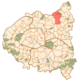
 Paris and inner ring departments |
||
| Coordinates: 48°56′19″N 2°29′26″E / 48.9386°N 2.4906°ECoordinates: 48°56′19″N 2°29′26″E / 48.9386°N 2.4906°E | ||
| Country | France | |
| Region | Île-de-France | |
| Department | Seine-Saint-Denis | |
| Arrondissement | Le Raincy | |
| Canton | Aulnay-sous-Bois | |
| Intercommunality | Paris Terres d'Envol | |
| Government | ||
| • Mayor (2014-2020) | Bruno Beschizza | |
| Area1 | 16.2 km2 (6.3 sq mi) | |
| Population (2013)2 | 82,634 | |
| • Density | 5,100/km2 (13,000/sq mi) | |
| Time zone | CET (UTC+1) | |
| • Summer (DST) | CEST (UTC+2) | |
| INSEE/Postal code | 93005 / 93600 | |
|
1 French Land Register data, which excludes lakes, ponds, glaciers > 1 km² (0.386 sq mi or 247 acres) and river estuaries. 2Population without double counting: residents of multiple communes (e.g., students and military personnel) only counted once. |
||
1 French Land Register data, which excludes lakes, ponds, glaciers > 1 km² (0.386 sq mi or 247 acres) and river estuaries.
Aulnay-sous-Bois (French pronunciation: [ɔnɛsubwa]) is a French commune in the Seine-Saint-Denis department in the Île-de-France region in the north-eastern suburbs of Paris, France. It is located 13.9 km (8.6 mi) from the Kilometre zero.
The inhabitants of the commune are known as Aulnaysiens or Aulnaysiennes.
The commune has been awarded four flowers by the National Council of Towns and Villages in Bloom in the Competition of cities and villages in Bloom.
Aulnay-sous-Bois is located in the Paris area and is 19 km north-east of Notre-Dame Cathedral, 1 km east of Le Bourget Airport, and 5 km south-west of Charles de Gaulle Airport. The commune stretches over a length of 6.5 km from north to south and a width ranging from 1.4 to 4.3 km from east to west and covers an area of 1,620 hectares.
The town is surrounded by the A3 autoroute in the west which joins the A1 autoroute in the north. Route nationale 2 passes through the heart of the commune from west to east with the N370 coming from the south-east along the eastern border to join the N2. The D44 passes through from north-west to south-east and the D115 from Bobigny in the south-west passes through the centre and continues to Villepinte in the east. The Ourcq Canal passes through the south-eastern end, adjacent to Livry-Gargan.
...
Wikipedia

