Augusta, Kentucky
| Augusta, Kentucky | |
|---|---|
| City | |

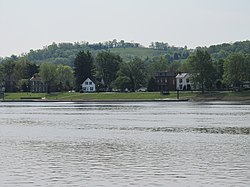
Houses along the Ohio River in Augusta
|
|
| Location within the state of Kentucky | |
| Coordinates: 38°46′18″N 84°0′21″W / 38.77167°N 84.00583°WCoordinates: 38°46′18″N 84°0′21″W / 38.77167°N 84.00583°W | |
| Country | United States |
| State | Kentucky |
| County | Bracken |
| Government | |
| • Mayor | John Laycock (2009–present) (R) |
| Area | |
| • Total | 1.6 sq mi (4.2 km2) |
| • Land | 1.4 sq mi (3.5 km2) |
| • Water | 0.3 sq mi (0.7 km2) 26.67% |
| Elevation | 515 ft (157 m) |
| Population (2010) | |
| • Total | 1,190 |
| • Density | 880/sq mi (339.8/km2) |
| Time zone | EST (UTC-5) |
| • Summer (DST) | EDT (UTC-4) |
| ZIP code | 41002 |
| Area code(s) | 606 Exchange: 759 |
| FIPS code | 21-02674 |
| GNIS feature ID | 0486141 |
| Website | www |
Augusta is a home rule-class city in Bracken County, Kentucky, in the United States. It is sited upon the southern bank of the Ohio River. As of the 2010 census, the city population was 1,190. When Bracken County was organized in 1796, Augusta was the county seat. In 1839, a new county courthouse was built at a more central location in Brooksville. The city was formally incorporated by the state assembly in 1850.
Augusta is located in northeastern Kentucky at 38°46′21″N 84°0′6″W / 38.77250°N 84.00167°W (38.772556, -84.001530).Kentucky Route 8 (Fifth Street) is the main road through the city. Route 8 leads northwest 42 miles (68 km) to downtown Cincinnati and southeast 19 miles (31 km) to Maysville. The Augusta Ferry crosses the Ohio River into Lewis Township, Brown County, Ohio, near Higginsport.
According to the United States Census Bureau, Augusta has a total area of 1.6 square miles (4.2 km2), of which 1.4 square miles (3.5 km2) is land and 0.27 square miles (0.7 km2), or 16.6%, is water.
...
Wikipedia

