Atimonan, Quezon
| Atimonan, Quezon | ||
|---|---|---|
| Municipality | ||
 |
||
|
||
| Motto: Pag nagtulungan, Panalo ang Bayan! | ||
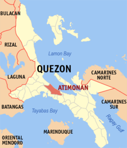
 Map of Quezon showing the location of Atimonan |
||
| Location within the Philippines | ||
| Coordinates: 14°00′N 121°55′E / 14.000°N 121.917°ECoordinates: 14°00′N 121°55′E / 14.000°N 121.917°E | ||
| Country | Philippines | |
| Region | Calabarzon (Region IV-A) | |
| Province | Quezon | |
| District | 4th district of Quezon | |
| Founded | February 4, 1608 | |
| Barangays | 42 | |
| Government | ||
| • Mayor | Engr. Rustico Joven Mendoza (Nacionalista) | |
| • Vice Mayor | Joel M. Vergano (UNA) | |
| Area | ||
| • Total | 239.66 km2 (92.53 sq mi) | |
| Population (2015) | ||
| • Total | 63,432 | |
| • Density | 260/km2 (690/sq mi) | |
| Demonym(s) | Atimonanin | |
| Time zone | PST (UTC+8) | |
| ZIP code | 4331 | |
| IDD : area code | +63 (0)42 | |
| Income class | 1st class; partially urban | |
| Website | www |
|
| Battle of Atimonan | |||||||
|---|---|---|---|---|---|---|---|
| Part of World War II, the 1944–1945 Philippine Campaign and Pacific War | |||||||
|
|||||||
| Belligerents | |||||||
|
|||||||
| Strength | |||||||
|
Philippine Common-wealth Military
Recognized Guerrilla Unit
United States Military
|
Imperial Japanese Military Japanese 14th Area Army Japanese 41st Area Army ~ 74,000 Japanese troops |
||||||
| Casualties and losses | |||||||
|
Philippine Commonwealth Military 6,800 killed 17,000 wounded Recognized Guerrilla Unit 480 killed 1,743 wounded United States Military 2,800 killed 5,320 wounded |
Imperial Japanese Military 28,000 killed 64,000 wounded 7,900 captured |
||||||
The Municipality of Atimonan (Filipino: Bayan ng Atimonan) or in (Spanish/Chavacano: El Pueblo de Atimonan) is a first class municipality in the province of Quezon, Philippines. It lies on the eastern shore of the province, 173 kilometres (107 mi) southeast of Manila. Atimonan is bounded by the municipalities of Gumaca, Plaridel, Pagbilao and Padre Burgos. According to the 2015 census, it has a population of 63,432 people.
Atimonan is politically subdivided into 42 barangays.
There were conflicting stories on how Atimonan got its name. Some concluded that the name Atimonan originated from a tree known as Atimon alleged to have been prevalent in the area and had reportedly served many uses to the residents. These trees are now extinct and its non-existence could not be accounted for.
Others say it came from the words atin muna, signifying a policy, unity of feeling and sentiments among the residents that bolster their spirit in the fight against their enemies during that time.
But the most popular version is that it originated from the name of its founder, Simeona Mangaba, known to her town mates as Ate Monang. She is a woman reputed to be of unquestionable leadership, which the people regarded as their adopted parent, leader and protector.
Ate Monang was the eldest sister of Francisco Mangaba, the first captain of the town. She founded the town on February 4, 1608 along the banks of the big Maling River, now known as Atimonan River.
Living along the river bank, the people has always been a prey to Moro attacks and so for fear of Moro reprisals, the inhabitants decided to transfer to Palsabangon, now a barrio of Pagbilao, Quezon. However, the people felt discontented in Palsabangon because the place abounds in wild crocodiles that from time to time disturbed them.
So, after two years of stay (1610), they left the place and transferred to Babyaw, a part of Atimonan. They settled in Babyaw for almost 14 years, but transferred again to another site called Minanukan for some unknown reasons.
...
Wikipedia


