Atacora
| Atakora | |
|---|---|
| Department | |
 |
|
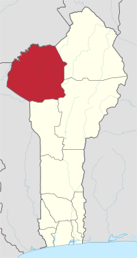
 Map highlighting the Atakora Department |
|
| Coordinates: 10°18′N 1°23′E / 10.300°N 1.383°ECoordinates: 10°18′N 1°23′E / 10.300°N 1.383°E | |
| Country |
|
| Capital | Natitingou |
| Area | |
| • Total | 20,499 km2 (7,915 sq mi) |
| Population (2013 census) | |
| • Total | 769,337 |
| • Density | 38/km2 (97/sq mi) |
| Time zone | WAT (UTC+1) |
Atakora is the northwestern department of Benin, bordering Togo to the west and Burkina Faso to the north. Also, it borders the departments of Alibori, Borgou, and Donga. Major towns in the Atakora include Natitingou and Tanguiéta, and the major tourist areas include the Tata Somba houses, the Pendjari National Park, and various waterfalls. The département of Atakora was bifurcated and some its southern territory were moved to the newly created Donga Department. The capital of the department is Natitingou.
Per 2013 census, the total population of the department was 772,262 with 380,448 males and 391,814 females. The proportion of women was 50.70 per cent. The total rural population was 62.80 percent, while the urban population was 37.20 per cent. The total labour force in the department was 170,333 out of which 27.20 per cent were women. The proportion of households with no level of education was 72.80
Benin is located in West Africa, bordered by Togo, Niger, Burkina Faso and Nigeria.The region is located in the northwest regions are usually forested mountains, from which the distributaries of the Niger River, namely, Mekarou and Penjari originate. The northern regions receive one season of rainfall from May to September, while the southern regions receive two spells from March to July and September to November. Harmattan winds blow from northeast during the months of December to March. The country receives an average annual rainfall of around 1,200 mm (47 in). The areas of the northwest region is mountainous and the Atakora Mountain Range extending till northeastern Togo is located in the region. The mountain range is also characterized by dambo areas (shallow wetlands) and head swamps.
...
Wikipedia
