Natitingou
| Natitingou | |
|---|---|
| Commune and city | |

Natitingou
|
|
| Location in Benin | |
| Coordinates: 10°18′N 1°22′E / 10.300°N 1.367°E | |
| Country |
|
| Department | Atakora Department |
| Area | |
| • Total | 3,045 km2 (1,176 sq mi) |
| Elevation | 426 m (1,398 ft) |
| Population (2013 census) | |
| • Total | 104,010 |
| • Density | 34/km2 (88/sq mi) |
| Time zone | WAT (UTC+1) |
Coordinates: 10°18′N 1°22′E / 10.300°N 1.367°E
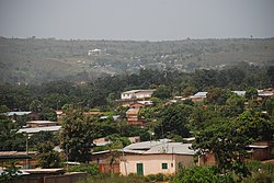
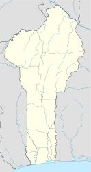
Natitingou is a city and commune in north western Benin. It is about 50 km from Benin's Pendjari National Park, where tourists can see West African wildlife during the months of December through June. The Falls of Tanougou and great mud castles of the Betammaribe known as Tata Somba are all within an hour or two of the town by car.
The commune covers an area of 3045 square kilometres and as of 2013 had a population of 104,010 people.
The town was founded by the Waama ethnic groups but is populated with Ditammari, Dendi, Nateni, Fulani, Fon, and many other ethnic groups. The region takes its name from the word Nantibatingou, the Waama root "Nanto" refers to "crush" as the local people were renowned growers and processor of sorghum which was native to the area and later millet.
Natitingou is evenly divided between Christians and Muslims and, like the rest of Benin, is notable for its ethnic and religious tolerance.
The mountains surrounding the region to the east and west sides are important in local animist beliefs and believed to be inhabited by spirits. Certain people subscribe to the idea that during the evening these spirits, emit sounds similar to those produced by stones which women uses to crush cereal grains. Adherents do not crush cereals in the evening, so as not to confuse the two sounds.
White missionaries visited Natitingou in the 19th century and early 20th century.
...
Wikipedia

