Assier
| Assier | ||
|---|---|---|
| Commune | ||

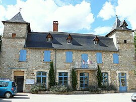
Assier Town Hall
|
||
|
||
| Coordinates: 44°40′34″N 1°52′39″E / 44.6761°N 1.8775°ECoordinates: 44°40′34″N 1°52′39″E / 44.6761°N 1.8775°E | ||
| Country | France | |
| Region | Occitanie | |
| Department | Lot | |
| Arrondissement | Figeac | |
| Canton | Livernon | |
| Intercommunality | Vallée et du Causse | |
| Government | ||
| • Mayor (2014–2020) | Patrick Roques | |
| Area1 | 16.49 km2 (6.37 sq mi) | |
| Population (2010)2 | 684 | |
| • Density | 41/km2 (110/sq mi) | |
| Time zone | CET (UTC+1) | |
| • Summer (DST) | CEST (UTC+2) | |
| INSEE/Postal code | 46009 /46320 | |
| Elevation | 294–420 m (965–1,378 ft) (avg. 342 m or 1,122 ft) |
|
|
1 French Land Register data, which excludes lakes, ponds, glaciers > 1 km² (0.386 sq mi or 247 acres) and river estuaries. 2Population without double counting: residents of multiple communes (e.g., students and military personnel) only counted once. |
||
1 French Land Register data, which excludes lakes, ponds, glaciers > 1 km² (0.386 sq mi or 247 acres) and river estuaries.
Assier is a French commune in the Lot department in the Occitanie region of south-western France.
The inhabitants of the commune are known as Assiérois or Assiéroises.
Assier is located some 12 km north-west of Figeac and some 18 km south-east of Gramat. The village is in the centre of the commune at the intersection of two highways: the D11 from Saint-Simon in the north-west which continues to Reyrevignes in the south-east and the D653 from Livernon in the south-west which continues to join the D840 north-east of the commune.
The Brive-la-Gaillarde to Rodez railway passes through the commune from north-west to south-east with a station just west of the village.
The highest parts of the commune are to the north-east (about 400 metres above sea level). The Limargue landscape provides grazing for cattle. A small stream flows with a slight slope parallel to the D653 in a wide valley flooded during heavy rain. After two ponds and an old mill, its water is lost near the centre of the village (altitude 350 metres).
In the south the rocky terrain forms a slightly undulating limestone plateau (320–330 metres above sea level) pierced by a few sinkholes around ten metres deep. This plateau is covered with short grass (dry grasslands) which supports flocks of sheep. There are also forests of contorted downy oaks that are used for firewood.
Assier is located at the end of an Early Jurassic formation called Limargue at the edge of the Causses limestone.
In the south-east the Causse de Gramat is composed of Karstified limestone from the Middle and Late Jurassic.
...
Wikipedia


