Asón valley
| Asón-Agüera | |||
|---|---|---|---|
| Comarca | |||
|
|||
 |
|||
| Country |
|
||
| Autonomous community | Cantabria | ||
| Province | Cantabria | ||
| Capital | Ramales de la Victoria | ||
| Municipalities | |||
| Area | |||
| • Total | 261.28 km2 (100.88 sq mi) | ||
| Population | |||
| • Total | 14,240 | ||
| • Density | 55/km2 (140/sq mi) | ||
| Demonym(s) | asonero, -a | ||
| Time zone | CET (UTC+1) | ||
| • Summer (DST) | CEST (UTC+2) | ||
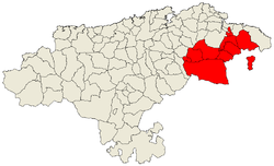
The Asón-Agüera comarca is a historical region of Cantabria, Spain. It is located in the upper courses of the Asón and Agüera rivers, near the border with Vizcaya in the Basque Country. The comarca encompasses the basin of the Asón river and its tributaries such as the Gándara.
The region was part of the historical territories of the Valley of Soba and Ruesga Villaverde, and the Merindad de Vecio (Junta de Parayas, Villas Laredo, Seña and clean, and Valle de Guriezo).
In 2006, the total population of the region (according to the INE) is 14,240 inhabitants (see table). The three most populated centers are: Ampuero (3,951), Ramales de Victoria (2,333) and Guriezo (2,101). Lesser populated places are: Valle de Villaverde (373) Arredondo (558) and Rasines (999).
Asón Valley is known for its rugged solid limestone, which house inside caving extraordinary wealth and majestic and interesting ancient forests of beech, oak and holm undoubtedly the most notable in the eastern part of Cantabria . Notably its beautiful scenery of mountains to the valleys with green meadows come together.
The valley is crossed by the Gandara River, a tributary of the Assos . Historical and municipal limits of Soba exceed those of geographically understood valley, and also include the head of the Ason, the right bank of the valley of the river Miera ( Valdició village in the municipality of Soba ) and the left bank of the valley of the river Calera, bordering with the province of Vizcaya.
Archaeological sites:
Vista aérea de Rasines.
Vista aérea de Ampuero.
Iglesia de la localidad de Seña, en Limpias.
Coordinates: 43°17′18″N 3°26′46″W / 43.2883°N 3.4461°W
...
Wikipedia
