Arundel, Quebec
| Arundel | |
|---|---|
| Township municipality | |
 |
|
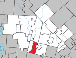
 Location within Les Laurentides RCM. |
|
| Location in central Quebec. | |
| Coordinates: 45°58′N 74°37′W / 45.967°N 74.617°WCoordinates: 45°58′N 74°37′W / 45.967°N 74.617°W | |
| Country |
|
| Province |
|
| Region | Laurentides |
| RCM | Les Laurentides |
| Settled | 1854 |
| Constituted | January 1, 1878 |
| Government | |
| • Mayor | Guylaine Berlinguette |
| • Federal riding | Laurentides—Labelle |
| • Prov. riding | Argenteuil |
| Area | |
| • Total | 66.90 km2 (25.83 sq mi) |
| • Land | 65.09 km2 (25.13 sq mi) |
| Population (2011) | |
| • Total | 604 |
| • Density | 9.3/km2 (24/sq mi) |
| • Pop 2006-2011 |
|
| • Dwellings | 400 |
| Demonym(s) | Arundelite |
| Time zone | EST (UTC−5) |
| • Summer (DST) | EDT (UTC−4) |
| Postal code(s) | J0T 1A0 |
| Area code(s) | 819 |
| Highways |
|
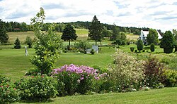
Arundel is a township municipality in Quebec, Canada, located 18 kilometres (11 mi) south of Mont Tremblant.
Arundel was settled by Scottish and Irish immigrants in the mid-19th century who established subsistence farming operations and worked the forests in winter.
Today most of the land is reserved for agricultural use despite strong growth in the region. Much of Arundel borders the Rouge River.
Population trend:
Private dwellings occupied by usual residents: 290 (total dwellings: 400)
Mother tongue:
...
Wikipedia

