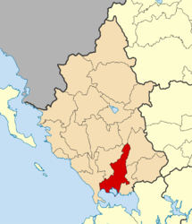
Arta, Greece
|
Arta Άρτα |
|
|---|---|

The historic Bridge of Arta.
|
|
| Coordinates: 39°9′N 20°59′E / 39.150°N 20.983°ECoordinates: 39°9′N 20°59′E / 39.150°N 20.983°E | |
| Country | Greece |
| Administrative region | Epirus |
| Regional unit | Arta |
| Government | |
| • Mayor | Ioannis Papalexis |
| Area | |
| • Municipality | 457.2 km2 (176.5 sq mi) |
| • Municipal unit | 47.973 km2 (18.522 sq mi) |
| Elevation | 30 m (100 ft) |
| Population (2011) | |
| • Municipality | 43,166 |
| • Municipality density | 94/km2 (240/sq mi) |
| • Municipal unit | 27,330 |
| • Municipal unit density | 570/km2 (1,500/sq mi) |
| Community | |
| • Population | 24,427 (2011) |
| Time zone | EET (UTC+2) |
| • Summer (DST) | EEST (UTC+3) |
| Postal code | 471 00 |
| Area code(s) | 26810 |
| Vehicle registration | ΑΤ |
| Website | www.arta.gr |
Arta (Greek: Άρτα) is a city in northwestern Greece, capital of the regional unit of Arta, which is part of Epirus region. The city was known in ancient times as Ambracia (Ancient Greek: Ἀμβρακία). Arta is known for the medieval bridge over the Arachthos River. Arta is also known for its ancient sites from the era of Pyrrhus of Epirus and its well-preserved 13th-century castle. Arta's Byzantine history is reflected in its many Byzantine churches; perhaps the best known is the Panagia Paregoretissa (Mother of God the Consoling), built about 1290 by Despot Nikephoros I Komnenos Doukas. The city is the seat of the Technological Educational Institute of Epirus.
The first settlement in the area of the modern city dates to the 9th century B.C. Ambracia was founded as a Corinthian colony in the 7th century B.C.
In 295 BC Pyrrhus of Epirus, king of the Molossians, transferred the capital of his kingdom to Ambracia, which he used as a base from which he attacked the Romans. Pyrrhus managed to achieve great but costly victories against the Romans, hence the phrase "Pyrrhic victory" which refers to an exchange at the Battle of Asculum. In 146 BC, Ambracia became part of the Roman Republic.
...
Wikipedia


