Arquà Petrarca
| Arquà Petrarca | |
|---|---|
| Comune | |
| Comune di Arquà Petrarca | |
 |
|
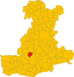
 The position of Arquà Petrarca within the province of Padua. |
|
| Location of Arquà Petrarca in Italy | |
| Coordinates: 45°16′12″N 11°43′06″E / 45.27000°N 11.71833°ECoordinates: 45°16′12″N 11°43′06″E / 45.27000°N 11.71833°E | |
| Country | Italy |
| Region | Veneto |
| Province / Metropolitan city | Padua (PD) |
| Government | |
| • Mayor | Luca Callegaro |
| Area | |
| • Total | 12.52 km2 (4.83 sq mi) |
| Population (2001) | |
| • Total | 1,876 |
| • Density | 150/km2 (390/sq mi) |
| Time zone | CET (UTC+1) |
| • Summer (DST) | CEST (UTC+2) |
| Postal code | 35032 |
| Dialing code | 0429 |
| Patron saint | Holy Trinity |
| Saint day | The first Sunday after Whitsunday |
| Website | Official website |
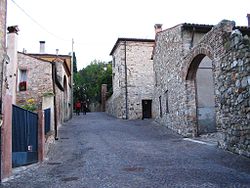
Arquà Petrarca [arˈkwa ppeˈtrarka] is a town and municipality (comune) in northeastern Italy, in the Veneto region, in the province of Padua. As of 2007 the estimated population of Arquà Petrarca was 1,835. The town is part of the club The most beautiful villages in Italy, and it has been awarded the Bandiera arancione award for excellence in tourism, hospitality and the environment.
Within the town boundaries lies the Coast Lake (Laghetto della Costa), one of the Prehistoric Pile Dwellings Around the Alps, since 2011 in the UNESCO World Heritage Sites list.
Arquà is the place where the poet Petrarch (Francesco Petrarca) lived the final four years of his life (1370–74). In 1870, the town of Arquà added his name to its own. The house where he lived is now a museum dedicated to the poet. The German international literary Petrarca-Preis awards were held in his residence in 1976 and 1977. In 2004, the 700th anniversary of the poet's birth was celebrated here and in nearby Padua.
Human presence in Arquà dates back to the Bronze Age, according to archaeological excavations made between the second half of the 19th century and the first decades of the 20th century. Afterwards, the territory was inhabited by the Eneti, and then annexed to the X Regio Venetia et Histria during the age of Augustus.
The legacy of the Roman domination is still present in toponyms (Bignago derives from Bennius, Mercurana from Mercurius) and archeological evidence, such as grave goods, imperial coins and sewage lines.
The village was probably established within a defensive line existing during the Barbaric age, connecting the Rocca of Monselice, a city at the center of the local political and administrative Longobard jurisdiction, with Valle San Giorgio, Cinto Euganeo and the plains at the east of the Euganean Hills.
...
Wikipedia

