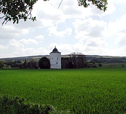
Arloff
| Arloff | |
|---|---|
| Stadt of Bad Münstereifel | |
 |
|
| Coordinates: 50°35′40″N 6°47′30″E / 50.594414°N 6.791567°ECoordinates: 50°35′40″N 6°47′30″E / 50.594414°N 6.791567°E | |
| Country | Germany |
| State | North Rhine-Westphalia |
| Municipality | Bad Münstereifel |
| Area | |
| • Total | 9.98 km2 (3.85 sq mi) |
| Elevation | 221 m (725 ft) |
| Population (2008-01-01) | |
| • Total | 1,139 |
| • Density | 110/km2 (300/sq mi) |
| Time zone | CET/CEST (UTC+1/+2) |
| Postal codes | 53902 |
| Dialling codes | 02253 |
Arloff is a village in the borough of Bad Münstereifel in the county of Euskirchen in the German state of North Rhine-Westphalia.
Arloff Castle is a well preserved fortified building from the early Gothic period.
Arloff lies in the Voreifel between Euskirchen and the old town of Bad Münstereifel on the boundary between the Zülpich Börde lowlands and the Eifel mountains.
The River Erft flows through the village. The Erft and the Landesstraße 194 are crossed by local roads that run along the edge of the Eifel. The urban area of Arloff and the village to the north, Kirspenich, merge here in the wide valley of the Erft.
...
Wikipedia

