Ariton, Alabama
| Ariton, Alabama | |
|---|---|
| Town | |
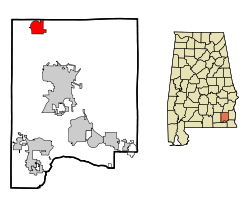
 Location in Dale County and the state of Alabama |
|
| Coordinates: 31°35′53″N 85°43′7″W / 31.59806°N 85.71861°W | |
| Country | United States |
| State | Alabama |
| County | Dale |
| Area | |
| • Total | 5.1 sq mi (13.2 km2) |
| • Land | 5.1 sq mi (13.2 km2) |
| • Water | 0 sq mi (0 km2) |
| Elevation | 459 ft (140 m) |
| Population (2010) | |
| • Total | 764 |
| • Density | 150/sq mi (58.0/km2) |
| Time zone | Central (CST) (UTC-6) |
| • Summer (DST) | CDT (UTC-5) |
| ZIP code | 36311 |
| Area code(s) | 334 |
| FIPS code | 01-02428 |
| GNIS feature ID | 0151663 |
Ariton is a town in Dale County, Alabama, United States. At the 2010 census the population was 764. It was incorporated in April 1906.
Ariton is part of the Ozark Micropolitan Statistical Area. And Serves as the home of the Purple Cats.
Ariton is located in northwestern Dale County at 31°35′54″N 85°43′8″W / 31.59833°N 85.71889°W (31.598204, -85.718761). Alabama State Routes 51 and 123 pass through the center of town as Main Street. AL 51 leads northeast 11 miles (18 km) to Clio and southwest 3.5 miles (5.6 km) to U.S. Route 231, while AL 123 leads west 3.5 miles (5.6 km) to US 231 and southeast 12 miles (19 km) to Ozark, the Dale County seat.
According to the U.S. Census Bureau, the town has a total area of 5.1 square miles (13.2 km2), all land.
As of the census of 2000, there were 772 people, 306 households, and 220 families residing in the town. The population density was 152.3 people per square mile (58.8/km2). There were 335 housing units at an average density of 66.1 per square mile (25.5/km2). The racial makeup of the town was 69.30% White, 29.27% Black or African American, 0.13% Native American, and 1.30% from two or more races. 0.78% of the population were Hispanic or Latino of any race.
...
Wikipedia
