Ozark, Alabama
| Ozark, Alabama | |
|---|---|
| City | |
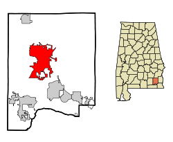
 Location in Dale County and the state of Alabama |
|
| Coordinates: 31°26′53″N 85°38′31″W / 31.44806°N 85.64194°W | |
| Country | United States |
| State | Alabama |
| County | Dale |
| Settled | 1822 |
| Incorporated | October 27, 1870 |
| Government | |
| • Type | Mayor/City Council |
| • Mayor | Billy Blackwell |
| Area | |
| • Total | 34.5 sq mi (89.3 km2) |
| • Land | 34.2 sq mi (88.7 km2) |
| • Water | 0.2 sq mi (0.6 km2) |
| Elevation | 417 ft (127 m) |
| Population (2010) | |
| • Total | 14,907 |
| • Estimate (2014) | 14,700 |
| • Density | 429/sq mi (165.7/km2) |
| Time zone | Central (CST) (UTC-6) |
| • Summer (DST) | CDT (UTC-5) |
| ZIP codes | 36360-36361 |
| Area code(s) | 334 |
| FIPS code | 01-57648 |
| GNIS feature ID | 0152832 |
| Website | www |
Ozark is a city in and the county seat of Dale County, Alabama, United States. As of the 2010 census, the population of the city was 14,907.
Ozark is the principal city of the Ozark Micropolitan Statistical Area, as well as a part of the Dothan-Enterprise-Ozark Combined Statistical Area. Fort Rucker, the primary flight training base for Army Aviation, abuts Ozark.
The Ozark area was originally inhabited by the Muscogee people. It is said that Ozark received its name after a traveler visited and was reminded of the Ozark Mountains in Arkansas.
The first known European settler in Ozark was John Merrick, Sr., a veteran of the Revolutionary War, in 1822. In honor of him, the town was named Merricks. It was later changed to Woodshop, which was its name when the town received its post office. The first appearance of the name Ozark was in 1855, when the citizens requested a name change.
The county seat was moved from Newton to Ozark 1870.
Ozark is home to three sites listed on the National Register of Historic Places: the Claybank Log Church, the Samuel Lawson Dowling House, and the J. D. Holman House.
Ozark is located at 31°26′53″N 85°38′31″W / 31.44806°N 85.64194°W (31.448169, −85.642009). It is part of the Wiregrass Region.
...
Wikipedia
