Argelès
| Argelès-sur-Mer | ||
|---|---|---|
| Commune | ||

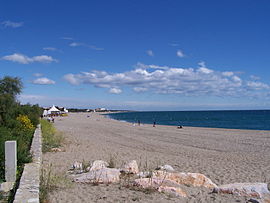
The beach at Argelès-sur-Mer
|
||
|
||
| Coordinates: 42°32′42″N 3°01′25″E / 42.5449°N 3.0235°ECoordinates: 42°32′42″N 3°01′25″E / 42.5449°N 3.0235°E | ||
| Country | France | |
| Region | Occitanie | |
| Department | Pyrénées-Orientales | |
| Arrondissement | Céret | |
| Canton | La Côte Vermeille | |
| Intercommunality | Communauté de communes des Albères et de la Côte Vermeille | |
| Government | ||
| • Mayor (2016–2020) | Antoine Parra | |
| Area1 | 58.67 km2 (22.65 sq mi) | |
| Population (2012)2 | 9,901 | |
| • Density | 170/km2 (440/sq mi) | |
| Time zone | CET (UTC+1) | |
| • Summer (DST) | CEST (UTC+2) | |
| INSEE/Postal code | 66008 /66700 | |
| Elevation | 0–1,099 m (0–3,606 ft) (avg. 16 m or 52 ft) |
|
|
1 French Land Register data, which excludes lakes, ponds, glaciers > 1 km² (0.386 sq mi or 247 acres) and river estuaries. 2Population without double counting: residents of multiple communes (e.g., students and military personnel) only counted once. |
||
1 French Land Register data, which excludes lakes, ponds, glaciers > 1 km² (0.386 sq mi or 247 acres) and river estuaries.
Argelès-sur-Mer (Catalan: Argelers de la Marenda or Argelers) is a commune in the Pyrénées-Orientales department in southern France.
It is about 25 km from Perpignan.
Argelès-sur-Mer is located in the canton of La Côte Vermeille and in the arrondissement of Céret.
Argelès-sur-Mer is on the Côte Vermeille at the foot of the Albères mountain range, close to the Spanish border. It has the longest beach in the Pyrenées Orientales.
During World War II, Argelès-sur-Mer was the location of a concentration camp, where up to 100,000 defeated Spanish Republicans were interned next to a windy beach in abysmal sanitary conditions by the French government after the defeat of the Spanish Republic. The refugees streamed to the camp from the winter of 1938/39 after the collapse of the Catalonian front following the rebel offensive.
Étoile sportive catalane is the rugby union club of Argelès-sur-Mer.
...
Wikipedia


