Arcangues
| Arcangues | ||
|---|---|---|

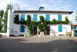
Arcangues Town Hall
|
||
|
||
| Coordinates: 43°26′15″N 1°31′11″W / 43.4375°N 1.5197°WCoordinates: 43°26′15″N 1°31′11″W / 43.4375°N 1.5197°W | ||
| Country | France | |
| Region | Nouvelle-Aquitaine | |
| Department | Pyrénées-Atlantiques | |
| Arrondissement | Bayonne | |
| Canton | Ustaritz | |
| Intercommunality | Errobi | |
| Government | ||
| • Mayor (2014–2020) | Philippe Echeverria | |
| Area1 | 17.47 km2 (6.75 sq mi) | |
| Population (2009)2 | 3,116 | |
| • Density | 180/km2 (460/sq mi) | |
| Time zone | CET (UTC+1) | |
| • Summer (DST) | CEST (UTC+2) | |
| INSEE/Postal code | 64038 /64200 | |
| Elevation | 4–140 m (13–459 ft) (avg. 60 m or 200 ft) |
|
|
1 French Land Register data, which excludes lakes, ponds, glaciers > 1 km² (0.386 sq mi or 247 acres) and river estuaries. 2Population without double counting: residents of multiple communes (e.g., students and military personnel) only counted once. |
||
1 French Land Register data, which excludes lakes, ponds, glaciers > 1 km² (0.386 sq mi or 247 acres) and river estuaries.
Arcangues (Basque: Arrangoitze) is a French commune in the Pyrénées-Atlantiques department in the Nouvelle-Aquitaine region of southwestern France in what was formerly the Basque province of Labourd.
The inhabitants of the commune are known as Arcanguais or Arcanguaises or Arrangoiztar in basque.
Arcangues belongs to the urban area of Bayonne and is located some 10 km south by south-west of Bayonne, 8 km south-east of Biarritz, and 6 km north-west of Ustaritz.
The A63 autoroute passes through the northern tip of the commune with the nearest exit being Exit ![]() 4 to the west of the commune but the slightly farther Exit
4 to the west of the commune but the slightly farther Exit ![]() 5 to the east connects directly to the D3 road which passes south through the commune and the village to Saint-Pée-sur-Nivelle. There is also the D755 which branches off the D3 in the north of the commune and continues south through the west of the commune to join the D255 on the commune's south-western border. The D933 road from Anglet to Ustaritz also passes through the eastern tip of the commune with a roundabout linking to country roads in the commune.
5 to the east connects directly to the D3 road which passes south through the commune and the village to Saint-Pée-sur-Nivelle. There is also the D755 which branches off the D3 in the north of the commune and continues south through the west of the commune to join the D255 on the commune's south-western border. The D933 road from Anglet to Ustaritz also passes through the eastern tip of the commune with a roundabout linking to country roads in the commune.
...
Wikipedia


