Arborea
| Arborea | ||
|---|---|---|
| Comune | ||
| Comune di Arborea | ||
 |
||
|
||
| Location of Arborea in Sardinia | ||
| Coordinates: 39°46′N 08°35′E / 39.767°N 8.583°E | ||
| Country | Italy | |
| Region | Sardinia | |
| Province / Metropolitan city | Oristano (OR) | |
| Frazioni | Centro I, Centro II, S'Ungroni, Luri, Linnas, Torrevecchia, Pompongias | |
| Government | ||
| • Mayor | Manuela Pintus | |
| Area | ||
| • Total | 115 km2 (44 sq mi) | |
| Elevation | 7 m (23 ft) | |
| Population (30 September 2014) | ||
| • Total | 4,005 | |
| • Density | 35/km2 (90/sq mi) | |
| Demonym(s) | Arborensi | |
| Time zone | CET (UTC+1) | |
| • Summer (DST) | CEST (UTC+2) | |
| Postal code | 09092 | |
| Dialing code | 0783 | |
| Patron saint | St. John Bosco | |
| Saint day | January 31 | |
| Website | Official website | |
Arborea is a town and comune in the province of Oristano, Sardinia, Italy, whose economy is largely based on agriculture, with production of vegetables, rice and fruit.
Arborea was built by the fascist government of Italy in the 1920s, after the draining of the marshes which covered the area. The village was populated by families, mostly composed of peasants, who came from the regions of Veneto and Friuli in north-eastern Italy.
Arborea is named for and lies within the medieval Giudicato of Arborea, which had its capital, at various periods, in nearby Tharros and Oristano. The town was originally named Villaggio Mussolini (with which it was inaugurated on October 29, 1928), by the fascist government. Less than two years later, the name was revised to Mussolinia di Sardegna ("Mussolinia of Sardinia", to distinguish the town from Mussolinia di Sicilia, now Santo Pietro in the commune of Caltagirone, Province of Catania). The current name was adopted after World War II.
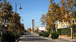
City Hall
Maria Ausiliatrice Square
Typical architecture
...
Wikipedia


