Anyksciai
| Anykščiai | ||
|---|---|---|
| City | ||

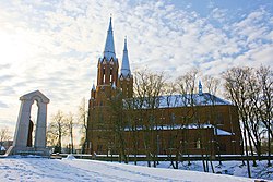
Anykščiai Church – the tallest church in Lithuania
|
||
|
||
| Location of Anykščiai | ||
| Coordinates: 55°32′N 25°6′E / 55.533°N 25.100°ECoordinates: 55°32′N 25°6′E / 55.533°N 25.100°E | ||
| Country |
|
|
| Ethnographic region | Aukštaitija | |
| County |
|
|
| Municipality | Anykščiai district municipality | |
| Eldership | Anykščiai eldership | |
| Capital of |
Anykščiai district municipality Anykščiai eldership |
|
| First mentioned | 1440 | |
| Granted city rights | 1516 | |
| Population (2001) | ||
| • Total | 11,958 | |
| Time zone | EET (UTC+2) | |
| • Summer (DST) | EEST (UTC+3) | |
Anykščiai (![]() pronunciation ; see other names) is a ski resort town in Lithuania, 20 miles (32 kilometres) west of Utena. The Roman Catholic Church of St. Matthias in Anykščiai is the tallest church in Lithuania, with spires measuring 79 metres (259 feet) in height.
pronunciation ; see other names) is a ski resort town in Lithuania, 20 miles (32 kilometres) west of Utena. The Roman Catholic Church of St. Matthias in Anykščiai is the tallest church in Lithuania, with spires measuring 79 metres (259 feet) in height.
The city has a football club FK Anykščiai.
Anykščiai is the Lithuanian name of the town. Its name in other languages includes Polish: Onikszty; Russian: Они́кшты (Onikshty); Belarusian: Ані́кшты (Anikshty); Yiddish: (Aniksht) אַניקשט; German: Onikschten.
Archeological research in the area has revealed settlements dating from the late Neolithic. Its location on the Šventoji River, connecting it to the Baltic Sea via the Neris River and Neman River, contributed to its development. It also lay on a land route between the cities of Vilnius and Riga. Its strategic importance led to frequent assaults by the Teutonic Order. The first written mention of the town dates to 1442; its first appearance on a map is dated tentatively to about 1578.
...
Wikipedia


