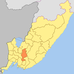
Anuchinsky District
| Anuchinsky District Анучинский район (Russian) |
|
|---|---|
 Location of Anuchinsky District in Primorsky Krai |
|
| Coordinates: 43°59′N 133°07′E / 43.983°N 133.117°ECoordinates: 43°59′N 133°07′E / 43.983°N 133.117°E | |
 The Arsenyevka River near the selo of Anuchino in Anuchinsky District |
|
|
|
|
| Location | |
| Country | Russia |
| Federal subject | Primorsky Krai |
| Administrative structure (as of June 2012) | |
| Administrative center | selo of Anuchino |
| Inhabited localities: | |
| Rural localities | 29 |
| Municipal structure (as of February 2006) | |
| Municipally incorporated as | Anuchinsky Municipal District |
| Municipal divisions: | |
| Urban settlements | 0 |
| Rural settlements | 4 |
| Statistics | |
| Area | 3,796.4 km2 (1,465.8 sq mi) |
| Population (2010 Census) | 14,613 inhabitants |
| • Urban | 0% |
| • Rural | 100% |
| Density | 3.85/km2 (10.0/sq mi) |
| Time zone | VLAT (UTC+10:00) |
| Established | March 23, 1935 |
| Official website | |
| on | |
Anuchinsky District (Russian: Ану́чинский райо́н) is an administrative and municipal district (raion), one of the twenty-two in Primorsky Krai, Russia. It is located in the south of the krai and borders with Spassky District in the north, Yakovlevsky District and the territory of Arsenyev Town Under Krai Jurisdiction in the northeast, Chuguyevsky District in the east, Partizansky District in the southeast, the territory of Partizansk Town Under Krai Jurisdiction in the south and southeast, Shkotovsky District in the south and southwest, and with Mikhaylovsky and Chernigovsky Districts in the west. The area of the district is 3,769.4 square kilometers (1,455.4 sq mi). Its administrative center is the rural locality (a selo) of Anuchino. Population: 14,613 (2010 Census);16,010 (2002 Census);18,187 (1989 Census). The population of Anuchino accounts for 30.5% of the district's total population.
...
Wikipedia


