Anthony, New Mexico
| Anthony, New Mexico | |
|---|---|
| City | |

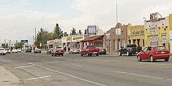
Main Street in Anthony, NM
|
|
| Nickname(s): old town | |
 Location of Anthony, New Mexico |
|
| Location in the United States | |
| Coordinates: 32°0′22″N 106°36′2″W / 32.00611°N 106.60056°WCoordinates: 32°0′22″N 106°36′2″W / 32.00611°N 106.60056°W | |
| Country | United States |
| State | New Mexico |
| County | Dona Ana |
| Incorporated | January 5, 2010 |
| Government | |
| • Mayor | Arnulfo Castañeda |
| Area | |
| • Total | 3.9 sq mi (10.2 km2) |
| • Land | 3.9 sq mi (10.2 km2) |
| • Water | 0.0 sq mi (0.0 km2) |
| Elevation | 3,802 ft (1,159 m) |
| Population (2010) | |
| • Total | 9,360 |
| • Density | 2,362.4/sq mi (912.1/km2) |
| Time zone | Mountain (MST) (UTC-7) |
| • Summer (DST) | MDT (UTC-6) |
| ZIP codes | 88021 |
| Area code(s) | 575 |
| FIPS code | 35-03820 |
| GNIS feature ID | 0920558 |
Anthony is a city in Doña Ana County, New Mexico, United States. The population was 9,360 at the 2010 census. It is located on the New Mexico–Texas state line in the Upper Mesilla Valley (immediately north of Anthony, Texas), and on Interstate 10, 27 miles south of Las Cruces and 21 miles north of El Paso, Texas. The city is part of the El Paso–Las Cruces combined statistical area.
In an election held on January 5, 2010, Anthony residents voted in favor of incorporating the community. A total of 561 votes were cast, with 410 (73.1%) supporting the measure and 151 (26.9%) opposed. The new municipality officially came into existence on July 1, 2010.
In its second elections held March 6, 2012 the City of Anthony voters elected two trustees, a new mayor and judge. The final results were as follows; for Mayor: Arnulfo Castañeda, 224 (winner); Juan Acevedo, 181, Two trustees: James Scott, 231 (winner); Pilar Madrid, 255 (winner); Janny Brumlow, 160, for Municipal judge: Peggy Scott, 340 (winner) The total number of ballots cast in the election was 1,391, according to a canvass certificate. Of those, 1,244 were cast on election day, 136 were cast in early voting and 11 were cast in absentee voting.
Anthony is located at 32°0′22″N 106°36′2″W / 32.00611°N 106.60056°W (32.006028, -106.600669).
According to the United States Census Bureau, the CDP has a total area of 3.9 square miles (10 km2), all land.
...
Wikipedia

