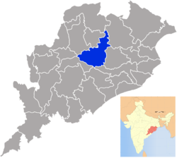
Angul district
|
Angul District ଅନୁଗୋଳ ଜିଲ୍ଲା |
|
|---|---|
| District | |
 |
|
| Coordinates: 20°49′59″N 85°06′00″E / 20.833°N 85.1°ECoordinates: 20°49′59″N 85°06′00″E / 20.833°N 85.1°E | |
| Country |
|
| State | Odisha |
| Established | 1 April 1993 |
| Headquarters | Angul |
| Government | |
| • Type | Municipality |
| • Collector | Shri Anil Kumar Samal [IAS] |
| Area | |
| • Total | 6,232 km2 (2,406 sq mi) |
| Elevation | 875.5 m (2,872.4 ft) |
| Population (2011) | |
| • Total | 1,271,703 |
| • Density | 199/km2 (520/sq mi) |
| Languages | |
| • Official | Odia, English |
| • Other local language | Ho |
| Time zone | IST (UTC+5:30) |
| PIN | 759122 |
| Telephone code | 06764 |
| Vehicle registration | OD-19/OR-19 |
| Nearest city(s) | Cuttack, Bhubaneswar, Sambalpur |
| Sex ratio | 0.942 ♂/♀ |
| Literacy | 78.96% |
| Vidhan Sabha constituency | 5 |
| Climate | Aw (Köppen) |
| Precipitation | 1,421 millimetres (55.9 in) |
| Average summer temperature | 47 °C (117 °F) |
| Average winter temperature | 10 °C (50 °F) |
| Website | www |
| General information | |
|---|---|
| Subdivisions: | 4 |
| Blocks: | 8 |
| Municipalities: | 2 |
| N.A.C.: | 1 |
| Tehsils: | 5 |
| Forest Coverage: | 2,716.82 km² |
| Villages: | 1,922 |
| Grama panchayat: | 180 |
| Towns: | 9 |
Angul(Odia: ) is a district of Odisha (Orissa) state in India. The city of Angul is the district headquarters.
Angul district (odia:ଅନୁଗୋଳ ଜିଲ୍ଲା) is located in the center of the state of Odisha and lies between 20° 31 N & 21° 40 N latitude and 84° 15 E & 85° 23 E longitude. The altitude is between 564 and 1187 metres. The district has an area of 6232 km2. It is bounded by Dhenkanal and Cuttack district in the east, Deogarh, Kendujhar and Sundargarh district in north, Sambalpur and Sonepur in west and Boudh and Nayagarh in the south side. The district is abundant with natural resources. Angul, The district headquarters is about 150 kilometers from the state capital Bhubaneswar.
It is the hottest district in India where maximum temperature goes up to 550C during summer.
A study jointly conducted by Indian Institute of Technology, Delhi (IIT-D) and Central Pollution Control Board (CPCB) reveals that Angul district is among the top ten most polluted Indian cities where the pollution level reached to a 'very alarmingly' level.
Angul district is divided into Blocks, Tehsils and subdivisions. They are: Subdivisions
Blocks
Tehsils
According to the 2011 census, Angul district has a population of 1,271,703, roughly equal to the nation of Estonia or the US state of New Hampshire. This gives it a ranking of 380th in India (out of a total of 640). The district has a population density of 199 inhabitants per square kilometre (520/sq mi) . Its population growth rate over the decade 2001-2011 was 11.55%. Anugul has a sex ratio of 942 females for every 1000 males, and a literacy rate of 78.96%.
...
Wikipedia
