Angres
| Angres | ||
|---|---|---|
| Commune | ||

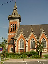
The church of Angres
|
||
|
||
| Coordinates: 50°24′35″N 2°45′33″E / 50.4097°N 2.7592°ECoordinates: 50°24′35″N 2°45′33″E / 50.4097°N 2.7592°E | ||
| Country | France | |
| Region | Hauts-de-France | |
| Department | Pas-de-Calais | |
| Arrondissement | Lens | |
| Canton | Bully-les-Mines | |
| Intercommunality | Lens-Liévin | |
| Government | ||
| • Mayor (2014-2020) | Maryse Coupin-Roger | |
| Area1 | 4.82 km2 (1.86 sq mi) | |
| Population (2014)2 | 4,202 | |
| • Density | 870/km2 (2,300/sq mi) | |
| Time zone | CET (UTC+1) | |
| • Summer (DST) | CEST (UTC+2) | |
| INSEE/Postal code | 62032 /62143 | |
| Elevation | 49–106 m (161–348 ft) (avg. 54 m or 177 ft) |
|
|
1 French Land Register data, which excludes lakes, ponds, glaciers > 1 km² (0.386 sq mi or 247 acres) and river estuaries. 2Population without double counting: residents of multiple communes (e.g., students and military personnel) only counted once. |
||
1 French Land Register data, which excludes lakes, ponds, glaciers > 1 km² (0.386 sq mi or 247 acres) and river estuaries.
Angres is a commune in the Pas-de-Calais department in the Hauts-de-France region of France.
A farming and light industrial suburb situated just 3 miles (4.8 km) southwest of Lens centre, at the junction of the D51 and D58e roads. The A26 autoroute passes by, just within the borders of the commune.
Angres is twinned with: ![]() Danderhall, Midlothian, Scotland.
Danderhall, Midlothian, Scotland.
...
Wikipedia


