Angalakuduru
| Angalakuduru | |
|---|---|
| Village | |

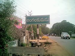
Signboard of Angalakuduru village
|
|
| Location in Andhra Pradesh, India | |
| Coordinates: 16°14′21″N 80°36′42″E / 16.23917°N 80.61167°ECoordinates: 16°14′21″N 80°36′42″E / 16.23917°N 80.61167°E | |
| Country | India |
| State | Andhra Pradesh |
| District | Guntur |
| Area | |
| • Total | 9.11 km2 (3.52 sq mi) |
| Elevation | 11 m (36 ft) |
| Population (2011) | |
| • Total | 9,920 |
| • Density | 1,100/km2 (2,800/sq mi) |
| Languages | |
| • Official | Telugu |
| Time zone | IST (UTC+5:30) |
Angalakuduru is a village in Guntur district of the Indian state of Andhra Pradesh. It is located in Tenali mandal of Tenali revenue division.
As of 2011[update]Census of India, Angalakuduru had a population of 9,920. The total population constitute, 4,819 males and 5,101 females — a sex ratio of 1059 females per 1000 males. 803 children are in the age group of 0–6 years, of which 402 are boys and 401 are girls. The average literacy rate stands at 77.75% with 7,088 literates, significantly higher than the state average of 67.41%.
Angalakuduru gram panchayat is the local self-government of the village. The panchayat has a total of 14 wards and each ward is represented by an elected ward member. The present sarpanch of the village is Vuriti Bhavani.B.Subbarao is the secretary of the panchayat.
Agriculture is the main occupation of the village and the main crops been cultivated are paddy, maize, black gram etc. Apart from it, there exists some small occupations such as weaving baskets, bags, mats etc., from water hyacinth.
Angalakuduru has road and rail connectivity. It lies on the Guntur–Tenali road passing through the village.Angalakuduru railway station is an F–category station on Guntur–Tenali section and is administered under Guntur railway division of South Central Railway zone.
...
Wikipedia


