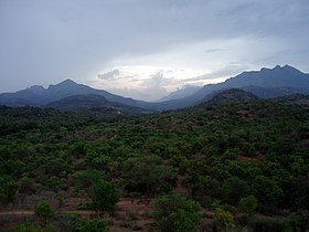
Anamalai
| Anamala / Anaimalai Hills Elephant Hill ആനമല/ஆனைமலை |
|
|---|---|

Chinnar Wildlife Sanctuary
|
|
| Highest point | |
| Peak | Anamudi / Anaimudi (Kerala) |
| Elevation | 2,695 m (8,842 ft) |
| Coordinates | 10°10′16″N 77°03′48″E / 10.17111°N 77.06333°E |
| Geography | |
| Country | India |
| States | Tamil Nadu and Kerala |
| Range coordinates | 10°22′N 77°07.5′E / 10.367°N 77.1250°ECoordinates: 10°22′N 77°07.5′E / 10.367°N 77.1250°E |
| Parent range | Western Ghats |
| Topo map | (Terrain) |
| Geology | |
| Age of rock |
Cenozoic 100 to 80 mya |
| Type of rock | Fault |
The Anamala or Anaimalai Hills, also known as the Elephant Hills, are the range of mountains that form the southern portion of the Western Ghats and span the border of Kerala and Tamil Nadu in Southern India. The name animala is derived from the Tamil/Malayalam words ana or anai, meaning elephant, and mala or malai, meaning hill — thus Elephant Hill.
Anamudi Peak (8,842 feet [2,695 metres]) lies at the extreme southwestern end of the range and is the highest peak in southern India. Palakkad Gap divides the Western Ghats to the north. The lower slopes of the hills now have coffee and tea plantations as well as teak forests of great economic value. Dense monsoon forests including rosewood, sandalwood, teak, and sago palms cover most of the region, which helps the coffee and tea plantations and teak plantations grow.
The Western Ghats and Anaimalai Sub-Cluster, including the Anaimalai Hills, are currently under consideration by the UNESCO World Heritage Committee for selection as a World Heritage Site.
The hills are located between 10° 13' and 10° 31' N. and 76° 52' and 77° 23' E with a central point of: 10°22′N 77°07.5′E / 10.367°N 77.1250°E. They are south of where the Western Ghats are broken by the Palakkad Gap, which in turn is south of the Nilgiri Hills. They border on Kerala to the Southwest and the Cardamom Hills to the southeast. The Palni Hills lie to the east.
...
Wikipedia

