Anakapalli
|
Anakapalli అనకాపల్లి |
|
|---|---|
| Neighbourhood | |

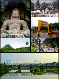
Anakapalle Montage
Clockwise from Top Left: Rock-cut Buddha Statue at Bojjannakonda, View of Anakaplli Town, Anakapalli railway Station, Streets of Anakapalli, Rail Bridge on Sarada River, View of Satyanarayana Konda |
|
| Location in Andhra Pradesh, India | |
| Coordinates: 17°41′29″N 83°00′14″E / 17.6913°N 83.0039°ECoordinates: 17°41′29″N 83°00′14″E / 17.6913°N 83.0039°E | |
| Country | India |
| State | Andhra Pradesh |
| District | Visakhapatnam |
| Area | |
| • Total | 23.28 km2 (8.99 sq mi) |
| Elevation | 29 m (95 ft) |
| Population (2011) | |
| • Total | 86,519 |
| • Density | 3,700/km2 (9,600/sq mi) |
| Languages | |
| • Official | Telugu |
| Time zone | IST (UTC+5:30) |
| PIN | 531001, 531002(gavarapalem) |
| Telephone code | 08924 |
Anakapalli is a suburb of Visakhapatnam in the Indian state of Andhra Pradesh. Anakapalle municipality was merged in 2012 with Greater Visakhapatnam Municipal Corporation. It has the second largest jaggery market of the country.
The town was originally under the rule of the Kalinga Empire (ancient Orissa), different dynasties ruled this region i.e. Chedi Kingdom of Kalinga (Orissa), Eastern Ganga dynasty of Orissa, Gajapati Kingdom of Orissa, Kakatiya, and Qutub Shahi empires. Around 1450, Kakarlapudi Appala Raju took over the rule of region under the Nawab of Arcot, with Anakapalle as his fortified headquarters. The saga of Anakapalle starts with a historian named "Tallapragada" place and found that Anakapalle. This was proved from the historical evidences found on Bojjana Konda. Satavahanas, Vishnukundina, Gajapathi's, Vijayanagara Samrats, Golkonda Samanta Rajulu ruled the area.
Its alias names are Aniankapalli, Anekaphalle, Vijaypuri, Veniapalii, Kanakapuri, Bellampatnam, and Anakapalli. It is located by the side of a holy Sarada River. During the Independence struggle of India, many prominent leaders like Mahatma Gandhi and Dr. B. R. Ambedkar visited Anakapalle. It is around 34 km in distance from Visakhapatnam.
...
Wikipedia

