Anabta
| Anabta | |
|---|---|
| Other transcription(s) | |
| • Arabic | عنبتا |
| • Also spelled | 'Anabta (official) 'Anabta and Iktaba (unofficial) |

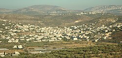
View of Anabta
|
|
| Location of Anabta within the Palestinian territories | |
| Coordinates: 32°18′25.80″N 35°07′01.00″E / 32.3071667°N 35.1169444°ECoordinates: 32°18′25.80″N 35°07′01.00″E / 32.3071667°N 35.1169444°E | |
| Palestine grid | 161/190 |
| Governorate | Tulkarm |
| Government | |
| • Type | Municipality |
| • Head of Municipality | Thabit Eimar |
| Population (2007) | |
| • Jurisdiction | 7,329 |
| Name meaning | grapes |
Anabta (Arabic: عنبتا) is a Palestinian town in the Tulkarm Governorate in the northern West Bank, located 9 kilometers east of Tulkarm. According to the Palestinian Central Bureau of Statistics, Anabta had a population of 7,329 inhabitants in 2007. Anabta is administered by a municipal council and is one of the oldest municipalities in the Tulkarm Governorate.
The name is likely derived from the word Enabta, which meant "grape" or "berry" in Jewish Aramaic and Syriac. Many grape presses have been found in the hills around the village.
During Roman and Byzantine rule over, Anabta was a Samaritan village. A tradition connects the village with Dositheos, a Samaritan religious leader possibly active during the 1st-century CE. The Samaritan chronicler Abu l-Fath (14th century) mentions that Dositheos died of starvation after going to 'Anbata where he hid in a cave, fasting in an effort to gain wisdom. Some olive trees still existing in Anabta are said to date back to Roman times.
According to the Palestine Exploration Fund's Survey of Western Palestine, the site appeared "ancient", and rock-cut tombs and a tank of good masonry had been found.
During the reign of Mamluk Sultan Baibars al-Bunduqdari in the 13th century, Anabta served as a central staging point from which to supply the Muslim armies fighting Crusader and Mongol incursions. The location was chosen because it was considered relatively easy to protect as the area is nestled between two large hills.
...
Wikipedia

