Anabarsky District
| Anabarsky District Анабарский улус (Russian) Анаабыр улууhа (Yakut) |
|
|---|---|
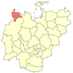
 Location of Anabarsky District in the Sakha Republic |
|
| Coordinates: 72°07′N 114°21′E / 72.117°N 114.350°ECoordinates: 72°07′N 114°21′E / 72.117°N 114.350°E | |
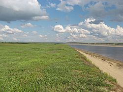
 Anabar River, Anabarsky District |
|
|
|
|
| Location | |
| Country | Russia |
| Federal subject | Sakha Republic |
| Administrative structure (as of June 2009) | |
| Administrative center | selo of Saskylakh |
| Administrative divisions: | |
| Rural okrugs | 3 |
| Inhabited localities: | |
| Rural localities | 3 |
| Municipal structure (as of April 2012) | |
| Municipally incorporated as | Anabarsky Municipal District |
| Municipal divisions: | |
| Urban settlements | 0 |
| Rural settlements | 2 |
| Statistics | |
| Area (June 2009) | 55,600 km2 (21,500 sq mi) |
| Population (2010 Census) | 3,501 inhabitants |
| • Urban | 0% |
| • Rural | 100% |
| Population (January 2016 est.) | 3,431 inhabitants |
| Density | 0.06/km2 (0.16/sq mi) |
| Time zone | YAKT (UTC+09:00) |
| Established | December 30, 1930 |
| on | |
| 2010 Census | 3,501 |
|---|---|
| 2002 Census | 4,024 |
| 1989 Census | 3,903 |
| 1979 Census | 2,161 |
Anabarsky District (Russian: Анаба́рский улу́с; Yakut: Анаабыр улууһа, Anaabır uluuha, IPA: [anaːbɯɾ uluːha]) is an administrative and municipal district (raion, or ulus), one of the thirty-four in the Sakha Republic, Russia. It is located in the northwest of the republic and borders with Bulunsky District in the east, Olenyoksky District in the south, and with Taymyrsky Dolgano-Nenetsky District of Krasnoyarsk Krai in the west. The area of the district is 55,600 square kilometers (21,500 sq mi). Its administrative center is the rural locality (a selo) of Saskylakh. As of the 2010 Census, the total population of the district was 3,501, with the population of Saskylakh accounting for 66.2% of that number.
The district is washed by the Laptev Sea in the north. The landscape of the district is mostly flat. The main river is the Anabar and the largest lake is Lake Sappyya.
Average January temperature ranges from −34 to −36 °C (−29 to −33 °F) and average July temperature ranges from +4 to +10 °C (39 to 50 °F). Average annual precipitation is 150–200 millimeters (5.9–7.9 in).
The district was established on December 30, 1930.
...
Wikipedia

