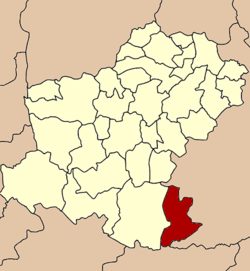
Amphoe Soeng Sang
|
Soeng Sang เสิงสาง |
|
|---|---|
| Amphoe | |
 Amphoe location in Nakhon Ratchasima Province |
|
| Coordinates: 14°25′34″N 102°27′38″E / 14.42611°N 102.46056°ECoordinates: 14°25′34″N 102°27′38″E / 14.42611°N 102.46056°E | |
| Country |
|
| Province | Nakhon Ratchasima |
| Seat | Soeng Sang |
| Area | |
| • Total | 1,200.2 km2 (463.4 sq mi) |
| Population (2010) | |
| • Total | 68,387 |
| • Density | 53.6/km2 (139/sq mi) |
| Time zone | THA (UTC+7) |
| Postal code | 30330 |
| Geocode | 3003 |
Soeng Sang (Thai: เสิงสาง) is a district (amphoe) in the southeastern part of Nakhon Ratchasima Province, northeastern Thailand.
The meaning of the district name in Thai is dawn or nearly dawn. The city temple is called Wat Thung Rung Arun Si Soeng Sang.
The area was separated from Khon Buri district and became a minor district (King Amphoe) on May 7, 1976. The minor district originally consisted of the single tambon Sa Takhian. It was officially upgraded to a full district on March 25, 1979.
Neighboring districts are (from the north clockwise) Nong Ki, Non Suwan, Pakham and Non Din Daeng of Buriram Province, Watthana Nakhon of Sa Kaeo Province, and Khon Buri of Nakhon Ratchasima Province.
One of the main attractions in Soeng Sang is the Chomtawan reservoir.
The district is subdivided into 6 subdistricts (tambon), which are further subdivided into 84 villages (muban). There are two townships (thesaban tambon) Soeng Sang and Non Sombun both covering part of same-named tambon. Each of the subdistricts has a Tambon administrative organization, responsible for the area not covered by the townships.
...
Wikipedia
