Amphoe Sam Phran
|
Sam Phran สามพราน |
|
|---|---|
| Amphoe | |
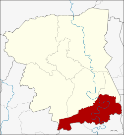
 Amphoe location in Nakhon Pathom Province |
|
| Coordinates: 13°43′27″N 100°13′0″E / 13.72417°N 100.21667°ECoordinates: 13°43′27″N 100°13′0″E / 13.72417°N 100.21667°E | |
| Country |
|
| Province | Nakhon Pathom |
| Seat | Sam Phran |
| Area | |
| • Total | 249.347 km2 (96.273 sq mi) |
| Population (2015) | |
| • Total | 203,108 |
| • Density | 814.55/km2 (2,109.7/sq mi) |
| Time zone | THA (UTC+7) |
| Postal code | 73110 |
| Geocode | 7306 |
Sam Phran (Thai: สามพราน, also written Sampran and Samphran; IPA: [sǎːm pʰrāːn]), is the southernmost district (Amphoe) of Nakhon Pathom Province, Thailand.
The district was established in 1896, then named Talat Mai district. It was renamed to Sam Phran in 1917.
The district is elongated in an East-West direction and neighbouring districts are (from the north clockwise) Mueang Nakhon Pathom, Nakhon Chai Si and Phutthamonthon of Nakhon Pathom Province, Thawi Watthana and Nong Khaem of Bangkok, Krathum Baen and Ban Phaeo of Samut Sakhon Province, and Bang Phae of Ratchaburi Province.
The main water resource of the district is the large Tha Chin river or Nakhon Chai Si river which meanders through the district in a south-easterly direction.
Sam Phran district has evolved as a ribbon development of tambons (sub districts) along Phetkasem Road, a major thoroughfare linking Bangkok with the cities of Nakhon Pathom and Kanchanaburi, their urban roadside appearance giving the aspect of a highly built up area. Behind the rows of shop-houses however, are compact 'village' communities of town houses with their own micro-infrastructure, factories and rice fields.
...
Wikipedia
