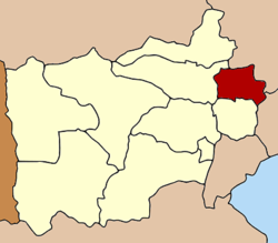
Amphoe Bang Phae
|
Bang Phae บางแพ |
|
|---|---|
| Amphoe | |
 Amphoe location in Ratchaburi Province |
|
| Coordinates: 13°41′29″N 99°55′49″E / 13.69139°N 99.93028°ECoordinates: 13°41′29″N 99°55′49″E / 13.69139°N 99.93028°E | |
| Country |
|
| Province | Ratchaburi |
| Seat | Bang Phae |
| Amphoe established | 1914 |
| Area | |
| • Total | 172.596 km2 (66.640 sq mi) |
| Population (2009) | |
| • Total | 44,562 |
| • Density | 248.8/km2 (644/sq mi) |
| Time zone | THA (UTC+7) |
| Postal code | 70160 |
| Geocode | 7006 |
Bang Phae (Thai: บางแพ, pronounced [bāːŋ pʰɛ̄ː]) is a district (Amphoe) in the eastern part of Ratchaburi Province, western Thailand.
The district was created in 1914 from 17 tambon from the districts Ban Pong, Photharam and Damnoen Saduak. At first a temporary district office was located in a pavillon of Wat Hua Pho in tambon Hua Pho. Originally named Lam Phraya (ลำพระยา), it was therefore renamed to Hua Pho in 1917. In 1939 it was finally renamed to Bang Phae, following the location of the district office since 1918 within tambon Bang Phae at the eastern short of the Bang Phae canal.
Neighboring districts are (from the south clockwise) Damnoen Saduak, Photharam of Ratchaburi Province, Mueang Nakhon Pathom, Sam Phran of Nakhon Pathom Province and Ban Phaeo of Samut Sakhon Province.
The district is subdivided into 7 subdistricts (tambon), which are further subdivided into 65 villages (muban). There are two subdistrict municipalities (thesaban tambon) - Bang Phae covers the complete tambon Bang Phae and Wang Yen, and Pho Hak the complete tambon Pho Hak. There are further 4 Tambon administrative organizations (TAO).
...
Wikipedia
