Altnau
| Altnau | ||
|---|---|---|
 |
||
|
||
| Coordinates: 47°37′N 9°15′E / 47.617°N 9.250°ECoordinates: 47°37′N 9°15′E / 47.617°N 9.250°E | ||
| Country | Switzerland | |
| Canton | Thurgau | |
| District | Kreuzlingen | |
| Area | ||
| • Total | 6.68 km2 (2.58 sq mi) | |
| Elevation | 398 m (1,306 ft) | |
| Population (Dec 2015) | ||
| • Total | 2,149 | |
| • Density | 320/km2 (830/sq mi) | |
| Postal code | 8595 | |
| SFOS number | 4641 | |
| Surrounded by | Güttingen, Hagnau am Bodensee (DE-BW), Langrickenbach, Münsterlingen, Stetten (DE-BW) | |
| Website |
www SFSO statistics |
|
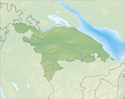
Altnau is a municipality in the district of Kreuzlingen in the canton of Thurgau in Switzerland.
Near the hamlet of Ruderbaum, the remains of a Horgen culture settlement have been discovered. Below the Horgen site, there may be also be Pfyn culture site, but that is less certain.
The modern village of Altnau may be first mentioned in 787 as Althinouva. In the 8th Century the Abbey of St. Gall owned most of the land in Altnau. In 1155, Emperor Friedrich Barbarossa confirmed that the Cathedral of Constance owned the church and church yard in the village. The vogt right over the church's farms belonged to the Freiherr of Altenklingen after 1300. During the Late Middle Ages, this right was given to several noble families from Constance; 1378 Schwarz, 1430 Tettikofen, 1468 Mangolte, and from 1471 until 1798 the city of Constance directly controlled the farms. In 1454 the villagers were represented in the Appenzell Landrecht, but following complaints from Constance they were forced to give up their membership. The rights of the village are first listed in the Gerichtsoffnung of 1468.
The right to administer the parish of Altnau went from the cathedral's provost to the cathedral's dean in 1347. After the Protestant Reformation in 1528, the few remaining Catholics were looked after by Constance and the village church became a shared church. This situation remained until 1810 when two churches were completed.
...
Wikipedia


