Almagreira
| Almagreira | |
| Civil Parish | |
|
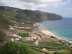
The village of Praia Formoso, on the southern coast of Almagreira; a resort and tourist center during the summer, attractive for its long white sand beach
|
|
| Official name: Freguesia da Almagreira | |
| Name origin: almagre, Portuguese for a type of lead-rich red clay used for pottery | |
| Country | |
|---|---|
| Autonomous region | |
| Island | Santa Maria |
| Municipality | Vila do Porto |
| Center | Almagreira |
| - elevation | 189 m (620 ft) |
| - coordinates | 36°57′57″N 25°6′24″W / 36.96583°N 25.10667°WCoordinates: 36°57′57″N 25°6′24″W / 36.96583°N 25.10667°W |
| Highest point | Pico Alto |
| - elevation | 579 m (1,900 ft) |
| - coordinates | 36°58′46″N 25°5′27″W / 36.97944°N 25.09083°W |
| Lowest point | Sea level |
| - location | Atlantic Ocean |
| - elevation | 0 m (0 ft) |
| Area | 11.22 km2 (4 sq mi) |
| - urban | .32 km2 (0 sq mi) |
| Population | 599 (2011) |
| Density | 53/km2 (137/sq mi) |
| LAU | Junta Freguesia |
| - location | Brejo de Baixo |
| - elevation | 190 m (623 ft) |
| - coordinates | 36°57′54″N 25°6′31″W / 36.96500°N 25.10861°W |
| Timezone | Azores (UTC-1) |
| - summer (DST) | Azores (UTC0) |
| Postal zone | 9580-014 |
| Area code & prefix | (+351) 292 XX XX XX |
| Patron saint | Nossa Senhora do Bom Despacho |
|
Location of the parish of Almagreira within the municipality of Vila do Porto
|
|
Almagreira (Portuguese pronunciation: [aɫmɐˈɡɾɐjɾɐ]) is a civil parish in the municipality of Vila do Porto in the Portuguese autonomous region of Azores. The population in 2011 was 599, in an area of 11.22 km². Bordering all other parishes of the island, it is located northwest of Vila do Porto.
It is unclear when this area was first referred to as Almagreira, but it stemmed from the exploration of a type of clay common in the area; from the name almagre, for a lead-rich red clay, used for pigment. The importance of this clay was later mentioned in a local poem:
The beachhead, today Praia Formosa, was first referred to in the Castillian Açores Insulae map, authored by Luís Teixeira and dated to 1584, as the Plaia Hermosa. The same author, in his map Descripçam da Ilha de Santa Maria, in 1587 (today located in the Biblioteca Nazionale Centrale de Florença), referred to the area of Almagreira as the Parish of Figueira (Portuguese: Paróquia da Figueira)”, noting the ancient hermitage dedicated to Nossa Senhora dos Remédios, and a small population of 40 neighbours, in addition to the aforementioned Praia Fremosa.
In addition to the Chapel of Nossa Senhora dos Remédios (Our Lady of Medicine), the parish is also the location of several other temples: Church of Nossa Senhora do Bom Despacho (Our Lady of Good Tidings), which evolved from a small chapel constructed in the 18th century, as well as the Church of Nossa Senhora do Monte (Our Lady of the Mount) and Nossa Senhora da Graça (Our Lady of Grace), both constructed in the 19th century.
It was in Porto Formosa that English (1599) and later Barbary coast pirates (June 1616) first attacked the island. The second assault, which was the most calamitous and damaging, resulted in islanders soliciting (formally, since about 1599) provisions for the islands defence.
...
Wikipedia


