Allos
| Allos | ||
|---|---|---|

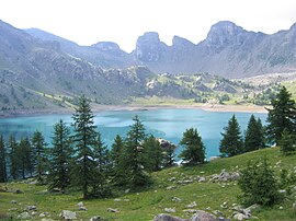
The Lac d'Allos
|
||
|
||
| Coordinates: 44°14′28″N 6°37′43″E / 44.2411°N 6.6286°ECoordinates: 44°14′28″N 6°37′43″E / 44.2411°N 6.6286°E | ||
| Country | France | |
| Region | Provence-Alpes-Côte d'Azur | |
| Department | Alpes-de-Haute-Provence | |
| Arrondissement | Castellane | |
| Canton | Allos-Colmars | |
| Intercommunality | Haut Verdon-Val d'Allos | |
| Government | ||
| • Mayor (2015-2020) | Marie-Annick Boizard | |
| Area1 | 116.65 km2 (45.04 sq mi) | |
| Population (2015)2 | 657 | |
| • Density | 5.6/km2 (15/sq mi) | |
| Time zone | CET (UTC+1) | |
| • Summer (DST) | CEST (UTC+2) | |
| INSEE/Postal code | 04006 /04260 | |
| Elevation | 1,339–3,040 m (4,393–9,974 ft) (avg. 1,425 m or 4,675 ft) |
|
|
1 French Land Register data, which excludes lakes, ponds, glaciers > 1 km² (0.386 sq mi or 247 acres) and river estuaries. 2Population without double counting: residents of multiple communes (e.g., students and military personnel) only counted once. |
||
1 French Land Register data, which excludes lakes, ponds, glaciers > 1 km² (0.386 sq mi or 247 acres) and river estuaries.
Allos is a French commune in the Alpes-de-Haute-Provence department in the Provence-Alpes-Côte d'Azur region of southeastern France.
Allos is a high mountain commune in the southern Alps. The commune experienced a significant rural exodus in the 19th century, following the population movement of the department. Then the town was overwhelmed for eighty years by winter sports: the construction of accommodations and ski-lifts has changed the landscape and the mountain urbanisation. The economy was profoundly altered with almost all jobs being found in tourism. Traditional agricultural activities persisted only marginally.
Historically Allos, located in the valley of the Verdon, has long been linked to the Ubaye Valley: first at the time when Ubaye belonged to the States of Savoy (from 1388 to 1713) then after it became part of France it continued to be administered across the Col d'Allos (impassable in winter). Even after the Revolution, it was attached to the Barcelonnette district. It was not until 1985 that it was (administratively) turned towards the valley by accepting the connection to the Canton of Colmars.
The inhabitants of the commune are known as Allossards or Allossardes
Allos is located some 12 km south of Barcelonnette and some 100 km north-west of Nice at an altitude of 1425 m. The Allos valley is traversed by the Verdon which has its source in the Foux d'Allos in the Sestriere valley at 2500 m altitude.
Access to the commune is by the D908 road: a tortuous road running off the D902 south of Barcelonette which passes through the heart of the commune and the village before continuing south to Colmars.
...
Wikipedia


