Allen Park, MI
| Allen Park, Michigan | |
|---|---|
| City | |
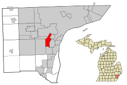
 Location in Wayne County and the state of Michigan |
|
| Location in the United States | |
| Coordinates: 42°15′17″N 83°12′37″W / 42.25472°N 83.21028°W | |
| Country | United States |
| State | Michigan |
| County | Wayne |
| Government | |
| • Mayor | William Matakas |
| Area | |
| • Total | 7.05 sq mi (18.26 km2) |
| • Land | 7.00 sq mi (18.13 km2) |
| • Water | 0.05 sq mi (0.13 km2) |
| Elevation | 594 ft (181 m) |
| Population (2010) | |
| • Total | 28,210 |
| • Estimate (2016) | 27,214 |
| • Density | 4,000/sq mi (1,500/km2) |
| Time zone | EST (UTC-5) |
| • Summer (DST) | EDT (UTC-4) |
| ZIP code | 48101-1952 |
| Area code(s) | 313 |
| FIPS code | 26-01380 |
| GNIS feature ID | 0619983 |
| Website | http://www.cityofallenpark.org/ |
Allen Park is a working-class suburb in central Wayne County, Michigan. The city is known for its tree-lined streets, brick houses, and the Fairlane Green Shopping Center that opened in 2006. At the 2010 census, the population was 28,210. The suburb of Detroit was once recognized in Money Magazine's list of America's Best Small Cities. Allen Park is part of the collection of communities known as Downriver. Much like other "Downriver" communities, Allen Park has seen a steady decline in recent years, in terms of property value.
Ford Motor Company is an integral part of the community. Many of the company's offices and facilities lie within the city limits. Since 2002, Allen Park is the practice home of the Detroit Lions football team and is also the site of the team's headquarters.
According to the United States Census Bureau, the city has a total area of 7.05 square miles (18.26 km2), of which 7.00 square miles (18.13 km2) is land and 0.05 square miles (0.13 km2) is water.
Allen Park borders Southgate to the South, Lincoln Park to the east, Melvindale to the north and northeast, Dearborn to the northwest, Dearborn Heights to the north, and Taylor to the west.
Fairlane Green, also known as "The Hill", is a shopping center located on a large hill between Outer Drive and Oakwood Boulevard. The site is a former clay quarry used to make bricks which was later purchased by Ford to use as a landfill for wastes from the Ford Rouge Plant. After the landfill closed in 2003, construction of retail stores began in 2006 with a focus on green prinicples. Independence Marketplace is a retail development between the hill and the freeway. It is built on top of the former location of Veterans Administration Hospital. In 1937, Henry and Clara Ford donated 38 acres at the corner of Southfield and Outer Drive for use as a Veterans Administration hospital. Ground-breaking ceremonies for the hospital were held on July 27, 1937, with Henry Ford in attendance. Major additions to the original hospital were made after WWII and during the 1960s. The Allen Park Veterans Administration Medical Center was sometimes referred to as the Dearborn VA Hospital. It was a long time landmark that was both beautiful and interesting in its architecture. The Allen Park VA hospital was deemed eligible for the National Register of Historic Places on Jan. 6, 1981 but in spite of this fact' it was demolished in 2004.
...
Wikipedia

