Alexandria, Missouri
| Alexandria, Missouri | |
|---|---|
| City | |
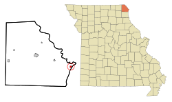
 Location of Alexandria, Missouri |
|
| Coordinates: 40°21′35″N 91°27′28″W / 40.35972°N 91.45778°WCoordinates: 40°21′35″N 91°27′28″W / 40.35972°N 91.45778°W | |
| Country | United States |
| State | Missouri |
| County | Clark |
| Area | |
| • Total | 0.39 sq mi (1.01 km2) |
| • Land | 0.38 sq mi (0.98 km2) |
| • Water | 0.01 sq mi (0.03 km2) |
| Elevation | 489 ft (149 m) |
| Population (2010) | |
| • Total | 159 |
| • Estimate (2012) | 156 |
| • Density | 418.4/sq mi (161.5/km2) |
| Time zone | Central (CST) (UTC-6) |
| • Summer (DST) | CDT (UTC-5) |
| ZIP code | 63430 |
| Area code(s) | 660 |
| FIPS code | 29-00604 |
| GNIS feature ID | 0735484 |
Alexandria is a city in Clark County, Missouri, USA. The population was 159 at the 2010 census.
Alexandria is part of the Fort Madison–Keokuk, IA-MO Micropolitan Statistical Area.
Alexandria was founded in the 1830s. The community was named after John Alexander, the proprietor of a nearby ferry. A post office called Alexandria has been in operation since 1840.
Alexandria is located at 40°21′35″N 91°27′28″W / 40.35972°N 91.45778°W (40.359770, -91.457749).
According to the United States Census Bureau, the city has a total area of 0.39 square miles (1.01 km2), of which, 0.38 square miles (0.98 km2) is land and 0.01 square miles (0.03 km2) is water.
Located along the Mississippi River, Alexandria is prone to flooding with large swaths of the area under water during the Great Flood of 1993.
As of the census of 2010, there were 159 people, 67 households, and 45 families residing in the city. The population density was 418.4 inhabitants per square mile (161.5/km2). There were 77 housing units at an average density of 202.6 per square mile (78.2/km2). The racial makeup of the city was 96.9% White, 0.6% African American, and 2.5% from two or more races.
...
Wikipedia
