Alcalde, NM
| Alcalde, New Mexico | |
|---|---|
| CDP | |

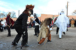
Los Matachines de Alcalde, 2013
|
|
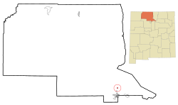
 Location of Alcalde, New Mexico |
|
| Location in the United States | |
| Coordinates: 36°5′17″N 106°3′25″W / 36.08806°N 106.05694°WCoordinates: 36°5′17″N 106°3′25″W / 36.08806°N 106.05694°W | |
| Country | United States |
| State | New Mexico |
| County | Rio Arriba |
| Area | |
| • Total | 0.5 sq mi (1.3 km2) |
| • Land | 0.5 sq mi (1.3 km2) |
| • Water | 0.0 sq mi (0.0 km2) |
| Elevation | 5,712 ft (1,741 m) |
| Population (2010) | |
| • Total | 285 |
| • Density | 570/sq mi (220/km2) |
| Time zone | Mountain (MST) (UTC-7) |
| • Summer (DST) | MDT (UTC-6) |
| ZIP code | 87511 |
| Area code(s) | 505 |
| FIPS code | 35-02070 |
| GNIS feature ID | 0928680 |
Alcalde is a census-designated place (CDP) in Rio Arriba County, New Mexico, United States. The population was 285 at the 2010 census. "Alcalde" literally means "Mayor" in Spanish.
According to the United States Census Bureau, the CDP has a total area of 0.5 square miles (1.3 km2), all of it land.
Alcalde has 1 elementary school which is part of the Española Public Schools.
The Oñate Monument Center (see Juan de Oñate) is located in Alcalde on New Mexico Highway 68.
As of the census of 2000, there were 377 people, 121 households, and 99 families residing in the CDP. The population density was 735.3 people per square mile (285.4/km²). There were 138 housing units at an average density of 269.2 per square mile (104.5/km²). The racial makeup of the CDP was 37.40% White, 0.27% African American, 1.59% Native American, 0.27% Asian, 54.64% from other races, and 5.84% from two or more races. Hispanic or Latino of any race were 89.12% of the population.
...
Wikipedia

