Albertville micropolitan area
| Marshall County, Alabama | |
|---|---|

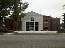
Marshall County Courthouse in Guntersville
|
|
 Location in the U.S. state of Alabama |
|
 Alabama's location in the U.S. |
|
| Founded | January 9, 1836 |
| Named for | John Marshall |
| Seat | Guntersville |
| Largest city | Albertville |
| Area | |
| • Total | 623 sq mi (1,614 km2) |
| • Land | 566 sq mi (1,466 km2) |
| • Water | 57 sq mi (148 km2), 9.2% |
| Population (est.) | |
| • (2016) | 95,157 |
| • Density | 164/sq mi (63/km²) |
| Congressional district | 4th |
| Time zone | Central: UTC-6/-5 |
| Website | www |
|
Footnotes:
|
|
Footnotes:
Marshall County is a county of the U.S. state of Alabama. As of the 2010 census the population was 93,019. Its county seat is Guntersville. A second courthouse is in Albertville. Its name is in honor of John Marshall, famous Chief Justice of the United States. Marshall County is a dry county, with the exception of the four cities of Albertville, Arab, Guntersville, and Boaz.
Marshall County comprises the Albertville, AL Micropolitan Statistical Area, which is also included in the Huntsville-Decatur-Albertville, AL Combined Statistical Area.
Marshall County was established on January 9, 1836.
According to the U.S. Census Bureau, the county has a total area of 623 square miles (1,610 km2), of which 566 square miles (1,470 km2) is land and 57 square miles (150 km2) (9.2%) is water. The Tennessee River runs both north and south within the county.
As of the census of 2000, there were 82,231 people, 32,547 households, and 23,531 families residing in the county. The population density was 145 people per square mile (56/km2). There were 36,331 housing units at an average density of 64 per square mile (25/km2). The racial makeup of the county was 93.38% White, 1.47% Black or African American, 0.53% Native American, 0.24% Asian, 0.04% Pacific Islander, 3.24% from other races, and 1.09% from two or more races. 5.66% of the population were Hispanic or Latino of any race.
...
Wikipedia
