Albany ny
| Albany, New York | |||
|---|---|---|---|
| City | |||
| City of Albany | |||

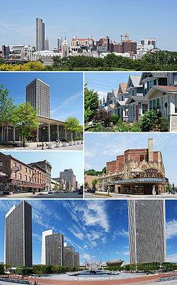
Clockwise from top: Albany skyline from Rensselaer; middle-class housing in the Helderberg neighborhood; Palace Theatre; Empire State Plaza from the Cultural Education Center; North Pearl Street at Columbia Street; and the State Quad at SUNY Albany.
|
|||
|
|||
| Etymology: Named for the Scottish Duke of Albany, whose title comes from the Gaelic name for Scotland: Alba | |||
| Motto: Assiduity | |||
 Boundaries of and major thoroughfares through Albany |
|||
 Location in Albany County and the state of New York. |
|||
| Coordinates: 42°39′09″N 073°45′26″W / 42.65250°N 73.75722°WCoordinates: 42°39′09″N 073°45′26″W / 42.65250°N 73.75722°W | |||
| Country |
|
||
| State |
|
||
| Region | Capital District | ||
| County | Albany | ||
| Settled | 1614 | ||
| Incorporation | 1686 | ||
| Government | |||
| • Type | Albany City Hall | ||
| • Mayor | Kathy Sheehan (D) | ||
| Area | |||
| • City | 56 km2 (21.8 sq mi) | ||
| • Land | 55 km2 (21.4 sq mi) | ||
| • Water | 1 km2 (0.4 sq mi) | ||
| • Metro | 17,000 km2 (6,570 sq mi) | ||
| Highest elevation (Near a reservoir off Birch Hill Road.) | 115 m (378 ft) | ||
| Lowest elevation (Sea level (at the Hudson River) | 0 m (0 ft) | ||
| Population (2015) | |||
| • City | 98,469 | ||
| • Density | 1,734.0/km2 (4,491.0/sq mi) | ||
| • Metro | 1,170,483 | ||
| • Metro density | 69/km2 (180/sq mi) | ||
| Time zone | Eastern (EST) (UTC-5) | ||
| • Summer (DST) | EDT (UTC-4) | ||
| ZIP Code | 12201-12, 12214, 12220, 12222-32 | ||
| Area code(s) | 518 | ||
| Geocode | 977310, 978659 | ||
| ISO 3166 code | 36-01000 | ||
| Demonym | Albanian | ||
| Website | www |
||
Albany (![]() i/ˈɔːlbəni/ AWL-bə-nee) is the capital of the U.S. state of New York and the seat of Albany County. Roughly 150 miles (240 km) north of New York City, Albany developed on the west bank of the Hudson River, about 10 miles (16 km) south of its confluence with the Mohawk River. The population of the City of Albany was 97,856 according to the 2010 census. Albany constitutes the economic and cultural core of the Capital District of New York State, which comprises the Albany-Schenectady-Troy, NY Metropolitan Statistical Area, including the nearby cities and suburbs of Troy, Schenectady, and Saratoga Springs. With a 2013 Census-estimated population of 1.1 million the Capital District is the third-most populous metropolitan region in the state and 38th in the United States.
i/ˈɔːlbəni/ AWL-bə-nee) is the capital of the U.S. state of New York and the seat of Albany County. Roughly 150 miles (240 km) north of New York City, Albany developed on the west bank of the Hudson River, about 10 miles (16 km) south of its confluence with the Mohawk River. The population of the City of Albany was 97,856 according to the 2010 census. Albany constitutes the economic and cultural core of the Capital District of New York State, which comprises the Albany-Schenectady-Troy, NY Metropolitan Statistical Area, including the nearby cities and suburbs of Troy, Schenectady, and Saratoga Springs. With a 2013 Census-estimated population of 1.1 million the Capital District is the third-most populous metropolitan region in the state and 38th in the United States.
...
Wikipedia


