Albany River
| Albany River | |
|
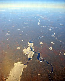
The Albany river between the Eabametoong First Nation (out of picture), and Marten Falls First Nation in the far distance downstream
|
|
| Name origin: named after James, Duke of York and Albany, later King James II of England | |
| Country | Canada |
|---|---|
| Province | Ontario |
| Region | Northern Ontario |
| Districts | Kenora, Thunder Bay, Cochrane |
| Part of | James Bay drainage basin |
| Tributaries | |
| - left | Pagashi River, Henley River, Etowamami River |
| - right | Cheepay River, Streatfeild River, Kenogami River, Ogoki River, Shabuskwia River, Misehkow River |
| Source | Lake St. Joseph |
| - elevation | 371 m (1,217 ft) |
| - coordinates | 51°11′40″N 90°13′20″W / 51.19444°N 90.22222°W |
| Mouth | James Bay |
| - location | Akimiski Strait |
| - elevation | 0 m (0 ft) |
| - coordinates | 52°17′00″N 81°30′59″W / 52.28333°N 81.51639°WCoordinates: 52°17′00″N 81°30′59″W / 52.28333°N 81.51639°W |
| Length | 982 km (610 mi) |
| Basin | 135,200 km2 (52,200 sq mi) |
| Discharge | |
| - average | 1,420 m3/s (50,147 cu ft/s) |
The Albany River is a river in Northern Ontario, Canada, which flows northeast from Lake St. Joseph in Northwestern Ontario and empties into James Bay. It is 982 kilometres (610 mi) long to the head of the Cat River (a tributary of Lake St. Joseph), tying it with the Severn River for the title of longest river in Ontario. Major tributaries include the Kenogami River and Ogoki River.
The river was named after James, Duke of York and Albany, who later became King James II of England.
The river begins at Lake St. Joseph at an elevation of 371 metres (1,217 ft). and flows over the Rat Rapids dam and under Ontario Highway 599 into Osnaburgh Lake. From there it flows via a Main Channel (northern) and South Channel around Kagami Island northeast, and takes in the right tributary Misehkow River and left tributary Etowamami River. The river continues over the Upper Eskakwa Falls, takes in the right tributary Shabuskwia River, and travels over the Eskakwa Falls and Snake Falls.
The river empties into the Akimiski Strait on James Bay via a series of channels. The community of Fort Albany lies on a southern channel and the Kashechewan First Nation on a northern one.
The river is navigable for the first 400 kilometres (249 mi).
This river drains an area of 135,200 square kilometres (52,201 sq mi) and has a mean discharge of 1,420 cubic metres (50,147 cu ft) per second. For much of its length, the river defines the boundary between Kenora District and Thunder Bay & Cochrane Districts.
...
Wikipedia


