Alapaha, Georgia
| Alapaha, Georgia | |
|---|---|
| Town | |

Alapaha City Hall
|
|
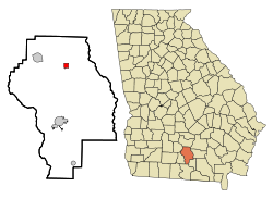
 Location in Berrien County and the state of Georgia |
|
| Coordinates: 31°22′56″N 83°13′26″W / 31.38222°N 83.22389°WCoordinates: 31°22′56″N 83°13′26″W / 31.38222°N 83.22389°W | |
| Country | United States |
| State | Georgia |
| County | Berrien |
| Area | |
| • Total | 1 sq mi (2.6 km2) |
| • Land | 1 sq mi (2.6 km2) |
| • Water | 0 sq mi (0 km2) |
| Elevation | 285 ft (87 m) |
| Population (2010) | |
| • Total | 668 |
| • Density | 682/sq mi (262.3/km2) |
| Time zone | Eastern (EST) (UTC-5) |
| • Summer (DST) | EDT (UTC-4) |
| ZIP code | 31622 |
| Area code(s) | 229 |
| FIPS code | 13-01024 |
| GNIS feature ID | 0331009 |
Alapaha is a town in Berrien County, Georgia, United States, along the Alapaha River. As of the 2010 census, the city had a population of 668.
Alapaha developed from a trade settlement on the site of a Seminole village with the same name. The present-day Georgia town of Lakeland was originally named "Alapaha" and existed before the town that now bears the name.
The Smithsonian Institution documented the presence of an Indian mound near Alapaha in 1886: "The Alapaha mound is situated 5 miles (8.0 km) northeast of the town of Alapaha, on Alapaha River, on lot of land No. 328, fifth district of Berrien County, Georgia. It is 38 feet (12 m) across, 6 feet (1.8 m) above the level, and somewhat oval in shape. In the center of the mound was a burial vault 6 feet (1.8 m) deep, 3 feet (0.91 m) wide, and 6 feet (1.8 m) long, north and south. Two bodies were deposited in this vault with the heads pointing south." It is possible that these remains became part of the Smithsonian collection, as was typical of its archaeological expeditions at the time. This source also gives the location and contents of two other Berrien County mounds south of Nashville, the Withlacoochee mound, and the French Ferry mound.
Early European settlers were primarily Highland Scots Methodist or Primitive Baptist, representing two socio-economic classes, "Jeffersonian yeomen" and a "squirearchy," two distinct divisions of landed farmers created by the Georgia Land Lottery of 1820. Between 1820 and 1840, agriculture was principally sheep and cattle herding. With the advent of railroad expansion in the 1830s a sizeable population of Irish Catholic laborers settled in and around the lower Alapaha River, eventually leading to the establishment of St. Anne's Catholic church there. Brushy Creek Primitive Baptist Church, originally in Irwin County, figured prominently in local affairs up to and after the Civil War. The Primitive Baptists often opposed the Methodist program of "benevolence" toward less fortunate citizens.
The town of Alapaha was established as a depot on the route of the Brunswick and Albany Railroad near where a road leading from Nashville, Georgia to Edenfield, Georgia crossed the Alapaha River. Early railroad maps refer to it as "Alapaha Station." It was in existence by at least 1874.
...
Wikipedia
